North Africa
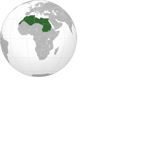
North Africa

| North Africa | |
|---|---|
| Countries | Other territories (3)
Unrecognized states (1)
|
| Time zones | UTC+00:00 UTC+01:00 UTC+02:00 |
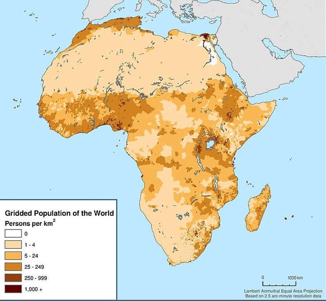
Population density of Africa (2000)
North Africa is a region encompassing the northern portion of the African continent. There is no singularly accepted scope for the region, and it is sometimes defined as stretching from the Atlantic shores of Mauritania in the west, to Egypt's Suez Canal and the Red Sea in the east. Others have limited it to the countries of Algeria, Morocco, and Tunisia, a region that was known by the French during colonial times as "Afrique du Nord" and is known by Arabs as the Maghreb ("West", The western part of Arab World). The most commonly accepted definition includes Morocco, Algeria, Tunisia, Libya, Egypt, and Sudan, the 6 countries that shape the top North of the African continent. Meanwhile, "North Africa", particularly when used in the term North Africa and the Middle East, often refers only to the countries of the Maghreb and Libya. Egypt, being also part of the Middle East, is often considered separately, due to being both North African and Middle Eastern at the same time.
North Africa includes a number of Spanish and Portuguese possessions, Plazas de soberanía, Ceuta and Melilla and the Canary Islands and Madeira.[4] The countries of North Africa share a common ethnic, cultural and linguistic identity that is unique to this region. Northwest Africa has been inhabited by Berbers since the beginning of recorded history, while the eastern part of North Africa has been home to the Egyptians.[5] Between the A.D. 600s and 1000s, Arabs from the Middle East swept across the region in a wave of Muslim conquest. These peoples, physically quite similar, formed a single population in many areas, as Berbers and Egyptians merged into Arabic and Muslim culture. This process of Arabization and Islamization has defined the cultural landscape of North Africa ever since.
The distinction between North Africa, the Sahel and the rest of the continent is as follows:
Nineteenth century European explorers, attracted by the accounts of Ancient geographers or Arab geographers of the classical period, followed the routes by the nomadic people of the vast "empty" space. They documented the names of the stopping places they discovered or rediscovered, described landscapes, took a few climate measurements and gathered rock samples. Gradually, a map began to fill in the white blotch. The Sahara and the Sahel entered the geographic corpus by way of naturalist explorers because aridity is the feature that circumscribes the boundaries of the ecumene. The map details included topographical relief and location of watering holes crucial to long crossings. The Arabic word "Sahel" (shore) and "Sahara" (desert) made its entry into the vocabulary of geography. Latitudinally, the "slopes" of the arid desert, devoid of continuous human habitation, descend in step-like fashion toward the northern and southern edges of the Mediterranean that opens to Europe and the Sahel that opens to "Trab al Sudan." Longitudinally, a uniform grid divides the central desert then shrinks back toward the Atlantic Ocean and the Red Sea. Gradually, the Sahara-Sahel is further divided into a total of twenty sub-areas: central, northern, southern, western, eastern, etc.
In this way, "standard" geography has determined aridity to be the boundary of the ecumene. It identifies settlements based on visible activity without regard for social or political organizations of space in vast, purportedly “empty” areas. It gives only cursory acknowledgement to what makes Saharan geography, and for that matter, world geography unique: mobility and the routes by which it flows.— An atlas of the Sahara-Sahel : geography, economics and security[6]
The Sahel or "African Transition Zone" has been affected by many formative epochs in North African history ranging from Ottoman occupation to the Arab-Berber control of the Andalus.[7][8] As a result, many modern African nation-states that are included in the Sahel evidence cultural similarities and historical overlap with their North African neighbours.[9] In the present day, North Africa is associated with West Asia in the realm of geopolitics to form a Middle East-North Africa region.[10] The Islamic influence in the area is also significant and North Africa is a major part of the Muslim world.
Some researchers have postulated that North Africa rather than East Africa served as the exit point for the modern humans who first trekked out of the continent in the Out of Africa migration.[11][12][13]
| North Africa | |
|---|---|
| Countries | Other territories (3)
Unrecognized states (1)
|
| Time zones | UTC+00:00 UTC+01:00 UTC+02:00 |
Geography
North Africa has three main geographic features: the Sahara desert in the south, the Atlas Mountains in the west, and the Nile River and delta in the east. The Atlas Mountains extend across much of northern Algeria, Morocco, and Tunisia. These mountains are part of the fold mountain system that also runs through much of Southern Europe. They recede to the south and east, becoming a steppe landscape before meeting the Sahara desert, which covers more than 75 percent of the region. The tallest peaks are in the High Atlas range in south-central Morocco, which has many snow-capped peaks.
South of the Atlas Mountains is the dry and barren expanse of the Sahara desert, which is the largest sand desert in the world.[14] In places the desert is cut by irregular watercourses called wadis—streams that flow only after rainfalls but are usually dry. The Sahara’s major landforms include ergs, large seas of sand that sometimes form into huge dunes; the hammada, a level rocky plateau without soil or sand; and the reg, a level plain of gravel or small stones. The Sahara covers the southern part of Algeria, Morocco and Tunisia, and most of Libya. Only two regions of Libya are outside the desert: Tripolitania in the northwest and Cyrenaica in the northeast. Most of Egypt is also desert, with the exception of the Nile River and the irrigated land along its banks. The Nile Valley forms a narrow fertile thread that runs along the length of the country.
Sheltered valleys in the Atlas Mountains, the Nile Valley and Delta, and the Mediterranean coast are the main sources of fertile farming land. A wide variety of valuable crops including cereals, rice and cotton, and woods such as cedar and cork, are grown. Typical Mediterranean crops, such as olives, figs, dates and citrus fruits, also thrive in these areas. The Nile Valley is particularly fertile, and most of the population in Egypt live close to the river. Elsewhere, irrigation is essential to improve crop yields on the desert margins.
Definitions
| Countries and territories | Area (2016) (km²) | Population (2016) | Density (2016) (per km²) | Capital | Total GDP[15] (2016) (US$billions) | GDP per capita[16] (2016) (US$) | Currency | Government | Official languages |
|---|---|---|---|---|---|---|---|---|---|
| 2,381,740 | 40,606,052 | 17.05 | Algiers | $160,784 | $15,281 | Algerian dinar | Presidential republic | Arabic and Berber (both official), French is commonly used | |
| 1,001,450 | 95,688,681 | 96 | Cairo | $332,349 | $12,554 | Egyptian pound | Semi-presidential republic | Arabic | |
| 1,759,540 | 6,293,253 | 3.58 | Tripoli | $33,157 | $8,678 | Libyan dinar | Provisional authority | Arabic | |
| 446,550 | 35,276,786 | 73.1 | Rabat | $103,615 | $8,330 | Moroccan dirham | Constitutional monarchy | Arabic and Berber (both official), French is commonly used | |
| 163,610 | 11,403,248 | 63 | Tunis | $41,869 | $11,634 | Tunisian dinar | Parliamentary republic | Arabic, French is commonly used. | |
| 18.5 | 82,376 | 4,500 | — | — | — | Euro (official), Moroccan dirham (porter trade)[17] | Autonomous city of a unitary parliamentary constitutional monarchy | Spanish | |
| 12.3 | 78,476 | 6,380.1 | — | — | — | Autonomous city of a unitary parliamentary constitutional monarchy | Spanish | ||
| Western Sahara | 266,000 | 538,755 | 0.37 | disputed | disputed | disputed | disputed | disputed | Disputed: commonly French and Arabic (Moroccan zone); commonly Spanish, Arabic (SADR zone) |
| Source: The World Bank[18] | |||||||||
Variously the Sudan and Western Sahara are considered to be part of the region by the United Nations,[19] while Western Sahara and Mauritania (but not Sudan) are included by the African Union.[20] In general geopolitical and business usage, as for example with the World Bank, North Africa is often grouped with the Middle East under the acronym MENA ("Middle East and North Africa") and sometimes in American governmental usage the geopolitical term Greater Middle East. Similarly, the traditional Arabic toponym Maghreb (meaning "the West") is commonly used to mean the African part of the Arab World, though usually with the exclusion of Egypt.
The inhabitants of the Spanish Canary Islands are of mixed Spanish and North African Berber ancestry, and the people of Malta are of North African ancestry and speak a derivative of Arabic. But these areas are not generally considered part of North Africa, but rather Southern Europe, due to their European-based cultures and religion.
People
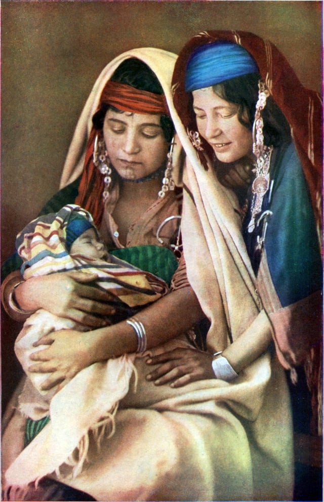
Women in Tunisia
The inhabitants of North Africa are roughly divided in a manner corresponding to the principal geographic regions of North Africa: the Maghreb, the Nile valley, and the Sahel. The Maghreb or western North Africa on the whole is believed to have been inhabited by Berbers since at least 10,000 B.C.,[21] while the eastern part of North Africa or the Nile Valley has mainly been home to the Egyptians. Ancient Egyptians record extensive contact in their Western desert with people that appear to have been Berber or proto-Berber. As the Tassili n'Ajjer and other rock art findings in the Sahara have shown, the Sahara also hosted various populations before its rapid desertification in 3500 B.C and even today continues to host small populations of nomadic trans-Saharan peoples.
In the eleventh century, the Banu Hilal invaded the North African plains and plateaus, but not the mountainous areas such as the Tell Atlas range, the Rif or the Aurès Mountains and brought with them Hilalian dialects of Arabic, which over the centuries have been in significant contact with other languages, including the languages of Europe. They have contributed to the Arabized Berber populations.
The official language or one of the official languages in all of the countries in North Africa is Arabic. Today, the largest ethnic groups in North Africa are Arabs, Berbers and West Africans. The region is predominantly Muslim with a Jewish minority in Morocco and Tunisia and significant Christian minority—the Copts—in Egypt, Algeria,[22] Morocco[23] and Tunisia.[24]
Culture
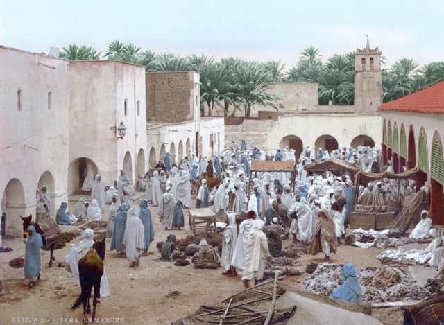
Market of Biskra in Algeria, 1899
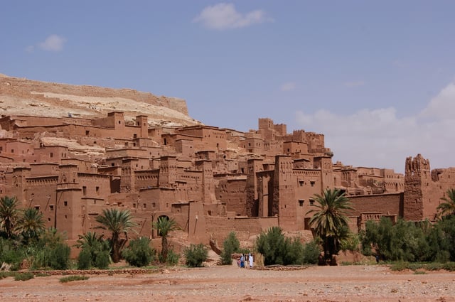
The kasbah of Aït Benhaddou in Morocco
The people of the Maghreb and the Sahara regions speak Berber languages and several varieties of Arabic and almost exclusively follow Islam. The Arabic and Berber languages are distantly related, both being members of the Afroasiatic language family. The Tuareg Berber languages are notably more conservative than those of the coastal cities.
Over the years, Berbers have been influenced by contact with other cultures: Greeks, Phoenicians, Egyptians, Romans, Vandals, Arabs, Europeans and Africans. The cultures of the Maghreb and the Sahara therefore combine indigenous Berber, Arab and elements from neighboring parts of Africa and beyond. In the Sahara, the distinction between sedentary oasis inhabitants and nomadic Bedouins and Tuaregs is particularly marked.
The diverse peoples of North Africa are usually categorized along ethno-linguistic lines. In the Maghreb, where Arab and Berber identities are often integrated, these lines can be blurred. Some Berber-speaking North Africans may identify as "Arab" depending on the social and political circumstances, although substantial numbers of Berbers (or Amazighen) have retained a distinct cultural identity which in the 20th century has been expressed as a clear ethnic identification with Berber history and language. Arabic-speaking Northwest Africans, regardless of ethnic background, often identify with Arab history and culture and may share a common vision with other Arabs. This, however, may or may not exclude pride in and identification with Berber and/or other parts of their heritage. Berber political and cultural activists for their part, often referred to as Berberists, may view all Northwest Africans as principally Berber, whether they are primarily Berber- or Arabic-speaking.
Egyptians over the centuries have shifted their language from Egyptian (in its late form, varieties of Coptic) to modern Egyptian Arabic while retaining a sense of national identity that has historically set them apart from other people in the region. Most Egyptians are Sunni Muslim, although there is a significant minority of Coptic Christians.
The Maghreb formerly had a significant Jewish population, almost all of whom emigrated to France or Israel when the North African nations gained independence. Prior to the modern establishment of Israel, there were about 600,000–700,000 Jews in Northern Africa, including both Sephardi Jews (refugees from France, Spain and Portugal from the Renaissance era) as well as indigenous Mizrahi Jews. Today, less than fifteen thousand remain in the region, almost all in Morocco and Tunisia, and are mostly part of a French-speaking urban elite. (See Jewish exodus from Arab and Muslim countries.)
History
Prehistory
Due to the recent African origin of modern humans, the history of Prehistoric North Africa is important to the understanding of pre-hominid and early modern human history in Africa. The earliest inhabitants of central North Africa have left behind significant remains: early remnants of hominid occupation in North Africa, for example, were found in Ain el Hanech, near Saïda (c. 200,000 BCE); in fact, more recent investigations have found signs of Oldowan technology there, and indicate a date of up to 1.8 million BCE.[25]
The cave paintings found at Tassili n'Ajjer, north of Tamanrasset, Algeria, and at other locations depict vibrant and vivid scenes of everyday life in central North Africa during the Neolithic Subpluvial period (about 8000 to 4000 BCE). Some parts of North Africa began to participate in the Neolithic revolution in the 6th millennium BCE, just before the rapid desertification of the Sahara around 3500 B.C. due to a tilt in the Earth's orbit.[26]
While Egypt due to the early civilizations of Ancient Egypt entered historicity by the Bronze Age, the Maghreb remained in the prehistoric period longer. Some Phoenician and Greek colonies were established along the Mediterranean coast during the 7th century BCE.
Antiquity and ancient Rome
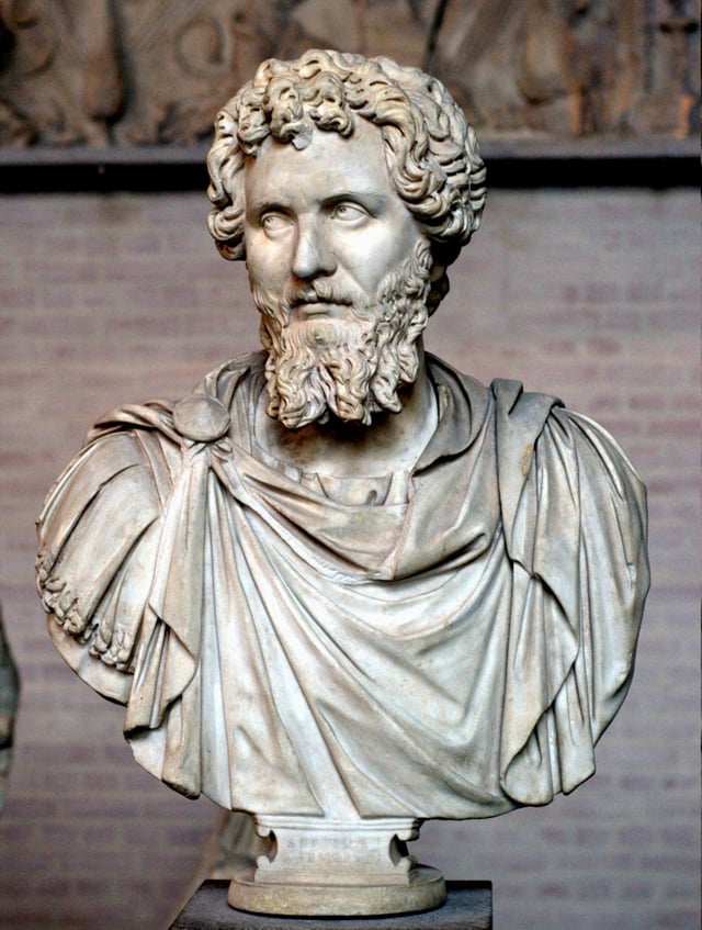
The first Roman emperor native to North Africa was Septimius Severus, born in Leptis Magna in present-day Libya.
The most notable nations of antiquity in western North Africa are Carthage and Numidia. The Phoenicians colonized much of North Africa including Carthage and parts of present-day Morocco (including Chellah, Essaouira and Volubilis[27]). The Carthaginians were of Phoenician origin, with the Roman myth of their origin being that Dido, a Phoenician princess, was granted land by a local ruler based on how much land she could cover with a piece of cowhide. She ingeniously devised a method to extend the cowhide to a high proportion, thus gaining a large territory. She was also rejected by the Trojan prince Aeneas according to Virgil, thus creating a historical enmity between Carthage and Rome, as Aeneas would eventually lay the foundations for Rome. Ancient Carthage was a commercial power and had a strong navy, but relied on mercenaries for land soldiers. The Carthaginians developed an empire in the Iberian Peninsula and Sicily, the latter being the cause of First Punic War with the Romans.
Over a hundred years and more, all Carthaginian territory was eventually conquered by the Romans, resulting in the Carthaginian North African territories becoming the Roman province of Africa in 146 B.C.[28] This led to tension and eventually conflict between Numidia and Rome. The Numidian wars are notable for launching the careers of both Gaius Marius, and Sulla, and stretching the constitutional burden of the Roman republic as Marius required a professional army, something previously contrary to Roman values, to overcome the talented military leader Jugurtha.[29]
North Africa remained a part of the Roman Empire, which produced many notable citizens such as Augustine of Hippo, until incompetent leadership from Roman commanders in the early fifth century allowed the Germanic peoples, the Vandals, to cross the Strait of Gibraltar, whereupon they overcame the fickle Roman defense. The loss of North Africa is considered a pinnacle point in the fall of the Western Roman Empire as Africa had previously been an important grain province that maintained Roman prosperity despite the barbarian incursions, and the wealth required to create new armies. The issue of regaining North Africa became paramount to the Western Empire, but was frustrated by Vandal victories. The focus of Roman energy had to be on the emerging threat of the Huns. In 468 AD, the Romans made one last serious attempt to invade North Africa but were repelled. This perhaps marks the point of terminal decline for the Western Roman Empire. The last Roman emperor was deposed in 476 by the Heruli general Odoacer. Trade routes between Europe and North Africa remained intact until the coming of Islam. Some Berbers were members of the Early African Church (but evolved their own Donatist doctrine),[30] some were Berber Jews, and some adhered to traditional Berber religion. African pope Victor I served during the reign of Roman emperor Septimius Severus
Arab conquest to modern times
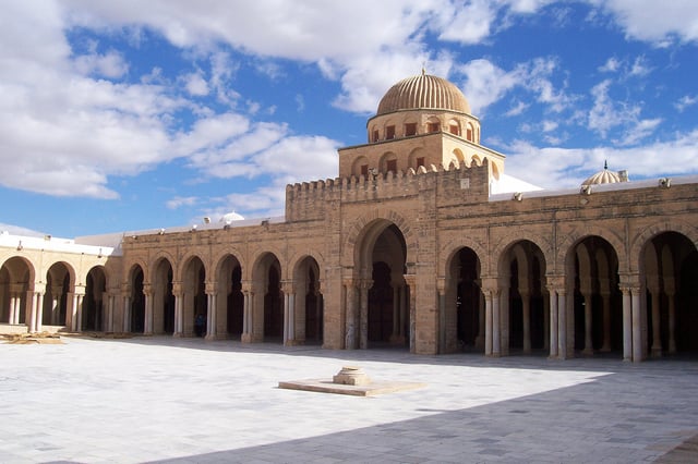
The Great Mosque of Kairouan in Tunisia, founded by Arab general Uqba ibn Nafi in 670, is one of the oldest and most important mosques in North Africa.[31]
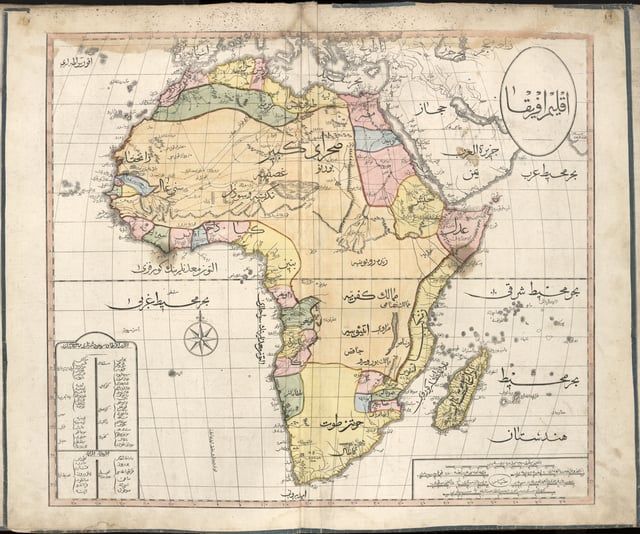
1803 Cedid Atlas, showing the Ottoman held regions of North Africa
The early Muslim conquests included North Africa by 640. By 700, most of North Africa had come under Muslim rule. Indigenous Berbers subsequently started to form their own polities in response in places such as Fez and Sijilmasa. In the eleventh century, a reformist movement made up of members that called themselves the Almoravid dynasty expanded south into Sub-Saharan Africa.
North Africa's populous and flourishing civilization collapsed after exhausting its resources in internal fighting and suffering devastation from the invasion of the Banu Sulaym and Banu Hilal. Ibn Khaldun noted that the lands ravaged by Banu Hilal invaders had become completely arid desert.[32]
After the Middle Ages the area was loosely under the control of the Ottoman Empire, except Morocco. The Spanish Empire conquered several coastal cities between the 16th and 18th centuries. After the 19th century, the imperial and colonial presence of France, the United Kingdom, Spain and Italy left the entirety of the region under one form of European occupation.
In World War II from 1940 to 1943 the area was the setting for the North African Campaign. During the 1950s and 1960s all of the North African states gained independence. There remains a dispute over Western Sahara between Morocco and the Algerian-backed Polisario Front.
In 2010–2011 massive protests swept the region leading to the overthrow of the governments in Tunisia and Egypt, as well as civil war in Libya. Large protests also occurred in Algeria and Morocco to a lesser extent. Many hundreds died in the uprisings. This uprising is commonly referred to as the "Arab spring"[33]
Science and technology
Transport and industry
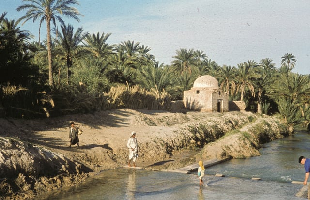
Thousands of people in North Africa depend on date palm trees for a living. Tunisia in 1960
The economies of Algeria and Libya were transformed by the discovery of oil and natural gas reserves in the deserts. Morocco's major exports are phosphates and agricultural produce, and as in Egypt and Tunisia, the tourist industry is essential to the economy. Egypt has the most varied industrial base, importing technology to develop electronics and engineering industries, and maintaining the reputation of its high-quality cotton textiles.
Oil rigs are scattered throughout the deserts of Libya and Algeria. Libyan oil is especially prized because of its low sulfur content, which means it produces much less pollution than other fuel oils.
See also
European Digital Archive on Soil Maps of the World
List of modern conflicts in North Africa
Demographics of the Middle East and North Africa