Norfolk

Norfolk

| Norfolk | |
|---|---|
| County | |
 | |
| Sovereign state | United Kingdom |
| Constituent country | England |
| Region | East of England |
| Established | Anglo-Saxon period[1] |
| Ceremonial county | |
| Lord Lieutenant | Richard Jewson |
| High Sheriff | Claire Margaret Agnew, Lady Agnew of Oulton (2019-)[2] |
| Area | 5,372 km2(2,074 sq mi) |
| • Ranked | 5th of 48 |
| Population (mid-2018 est.) | 898,400 |
| • Ranked | 25th of 48 |
| Density | 166/km2(430/sq mi) |
| Ethnicity | 96.5% white[3] |
| Non-metropolitan county | |
| County council |  Norfolk County Council |
| Executive | Conservative |
| Admin HQ | Norwich |
| Area | 5,372 km2(2,074 sq mi) |
| • Ranked | of 27 |
| Population | 898,400 |
| • Ranked | 7th of 27 |
| Density | 166/km2(430/sq mi) |
| ISO 3166-2 | GB-NFK |
| ONS code | 33 |
| NUTS | UKH13 |
| Website | www.norfolk.gov.uk [54] |
 Districts of Norfolk | |
| Districts |
|
| Members of Parliament |
|
| Police | Norfolk Constabulary |
| Time zone | Greenwich Mean Time (UTC) |
| • Summer (DST) | British Summer Time (UTC+1) |
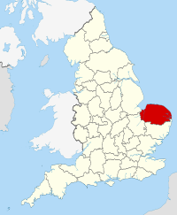
Norfolk (/ˈnɔːrfək/) is a county in East Anglia in England. It borders Lincolnshire to the northwest, Cambridgeshire to the west and southwest, and Suffolk to the south. Its northern and eastern boundaries are the North Sea and to the north-west, The Wash. The county town is Norwich. With an area of 2,074 square miles (5,370 km2) and a population of 859,400, Norfolk is a largely rural county with a population density of 401 per square mile (155 per km2). Of the county's population, 40% live in four major built up areas: Norwich (213,000), Great Yarmouth (63,000), King's Lynn (46,000) and Thetford (25,000).[4]
| Norfolk | |
|---|---|
| County | |
 | |
| Sovereign state | United Kingdom |
| Constituent country | England |
| Region | East of England |
| Established | Anglo-Saxon period[1] |
| Ceremonial county | |
| Lord Lieutenant | Richard Jewson |
| High Sheriff | Claire Margaret Agnew, Lady Agnew of Oulton (2019-)[2] |
| Area | 5,372 km2(2,074 sq mi) |
| • Ranked | 5th of 48 |
| Population (mid-2018 est.) | 898,400 |
| • Ranked | 25th of 48 |
| Density | 166/km2(430/sq mi) |
| Ethnicity | 96.5% white[3] |
| Non-metropolitan county | |
| County council |  Norfolk County Council |
| Executive | Conservative |
| Admin HQ | Norwich |
| Area | 5,372 km2(2,074 sq mi) |
| • Ranked | of 27 |
| Population | 898,400 |
| • Ranked | 7th of 27 |
| Density | 166/km2(430/sq mi) |
| ISO 3166-2 | GB-NFK |
| ONS code | 33 |
| NUTS | UKH13 |
| Website | www.norfolk.gov.uk [54] |
 Districts of Norfolk | |
| Districts |
|
| Members of Parliament |
|
| Police | Norfolk Constabulary |
| Time zone | Greenwich Mean Time (UTC) |
| • Summer (DST) | British Summer Time (UTC+1) |
History
Norfolk was settled in pre-Roman times, with camps along the higher land in the west, where flints could be quarried.[7] A Brythonic tribe, the Iceni, inhabited the county from the 1st century BC to the end of the 1st century AD. The Iceni revolted against the Roman invasion in AD 47, and again in 60 led by Boudica. The crushing of the second rebellion opened the county to the Romans. During the Roman era roads and ports were constructed throughout the county and farming was widespread.
Situated on the east coast, Norfolk was vulnerable to invasions from Scandinavia and Northern Europe, and forts were built to defend against the Angles and Saxons. By the 5th century the Angles, after whom East Anglia and England itself are named, had established control of the region and later became the "north folk" and the "south folk", hence, "Norfolk" and "Suffolk". Norfolk, Suffolk and several adjacent areas became the kingdom of East Anglia (one of the heptarchy), which later merged with Mercia and then with Wessex. The influence of the Early English settlers can be seen in the many place names ending in "-ton" and "-ham". Endings such as "-by" and "-thorpe" are also common, indicating Danish place names: in the 9th century the region again came under attack, this time from Danes who killed the king, Edmund the Martyr.
In the centuries before the Norman Conquest the wetlands of the east of the county began to be converted to farmland, and settlements grew in these areas. Migration into East Anglia must have been high: by the time of the Domesday Book survey it was one of the most densely populated parts of the British Isles. During the high and late Middle Ages the county developed arable agriculture and woollen industries. Norfolk's prosperity at that time is evident from the county's large number of medieval churches: out of an original total of over one thousand, 659 have survived, more than in the whole of the rest of Great Britain.[8] The economy was in decline by the time of the Black Death, which dramatically reduced the population in 1349.
Kett's Rebellion occurred in Norfolk during the reign of Edward VI, largely in response to the enclosure of land by landlords, leaving peasants with nowhere to graze their animals and the general abuses of power by the nobility. It was led by Robert Kett a yeoman farmer, who was joined by recruits from Norwich and the surrounding countryside. His group numbered some 16,000 by the time the rebels stormed Norwich on 29 July 1549 and took the city. Kett's rebellion ended on 27 August when the rebels were defeated by an army under the leadership of John Dudley, 1st Duke of Northumberland at the Battle of Dussindale. Some 3,000 rebels were killed. Kett was captured, held in the Tower of London, tried for treason, and hanged from the walls of Norwich Castle.[9][10][11]
By the late 16th century Norwich had grown to become the second-largest city in England, but over one-third of its population died in the plague epidemic of 1579,[12] and in 1665 the Great Plague again killed around one-third of the population.[13] During the English Civil War Norfolk was largely Parliamentarian. The economy and agriculture of the region declined somewhat. During the Industrial Revolution Norfolk developed little industry except in Norwich which was a late addition to the railway network.
In the 20th century the county developed a role in aviation. The first development in airfields came with the First World War; there was then a massive expansion during the Second World War with the growth of the Royal Air Force and the influx of the American USAAF 8th Air Force which operated from many Norfolk airfields.
For the local army regiments the Royal Norfolk Regiment and the Norfolk Yeomanry please click on the links.
During the Second World War agriculture rapidly intensified, and it has remained very intensive since, with the establishment of large fields for growing cereals and oilseed rape.
Management of the shoreline
Norfolk's low-lying land and easily eroded cliffs, many of which are composed of chalk and clay, make it vulnerable to weathering by the sea. The most recent major erosion event occurred during the North Sea flood of 1953.
The low-lying section of coast between Kelling and Lowestoft Ness in Suffolk is currently managed by the British Environment Agency to protect the Broads from sea flooding. Management policy for the North Norfolk coastline is described in the "North Norfolk Shoreline Management Plan" published in 2006, but has yet to be accepted by local authorities.[14] The Shoreline Management Plan states that the stretch of coast will be protected for at least another 50 years, but that in the face of sea level rise and post-glacial lowering of land levels in the South East, there is an urgent need for further research to inform future management decisions, including the possibility that the sea defences may have to be realigned to a more sustainable position. Natural England have contributed some research into the impacts on the environment of various realignment options. The draft report of their research was leaked to the press, who created great anxiety by reporting that Natural England plan to abandon a large section of the Norfolk Broads, villages and farmland to the sea to save the rest of the Norfolk coastline from the impact of climate change.[15]
Economy and industry
In 1998 Norfolk had a Gross Domestic Product of £9,319 million, which represents 1.5% of England's economy and 1.25% of the United Kingdom's economy. The GDP per head was £11,825, compared to £13,635 for East Anglia, £12,845 for England and £12,438 for the United Kingdom. In 1999–2000 the county had an unemployment rate of 5.6%, compared to 5.8% for England and 6.0% for the UK.[16]
Data from 2017 provided a useful update on the county's economy. The median hourly gross pay was £12.17 and the median weekly pay was £496.80; on a per year basis, the median gross income was £25,458. The employment rate among persons aged 16 to 64 was 74.2% while the unemployment rate was 4.6%.[17] The Norfolk economy was "treading water with manufacturing sales and recruitment remaining static in the first quarter of the year" according to research published in April 2018. A spokesperson for the Norfolk Chamber of Commerce made this comment: "At a time when Norfolk firms face steep up-front costs, the apprenticeship system is in crisis, roads are being allowed to crumble, mobile phone and broadband 'not-spots' are multiplying, it's obvious that the key to improved productivity and competitiveness lies in getting the basics right". The solution was seen as a need for the UK government to provide "a far stronger domestic economic agenda ... to fix the fundamentals needed for business to thrive here..."[18]
In 2017, tourism was adding £3.25 billion to the economy per year and supported some 65,000 jobs, being the fifth most important employment in Norfolk. The visitor economy had increased in value by more than £500 million since 2012. [19]
Important business sectors also include energy (oil, gas and renewables), advanced engineering and manufacturing, and food and farming.
Much of Norfolk's fairly flat and fertile land has been drained for use as arable land. The principal arable crops are sugar beet, wheat, barley (for brewing) and oil seed rape. The county also boasts a saffron grower.[20] Over 20% of employment in the county is in the agricultural and food industries.[21]
Well-known companies in Norfolk are Aviva (formerly Norwich Union), Colman's (part of Unilever), Lotus Cars and Bernard Matthews Farms. The Construction Industry Training Board is based on the former airfield of RAF Bircham Newton. The BBC East region is centred on Norwich, although it covers an area as far west as Milton Keynes; the BBC does however provide BBC Radio Norfolk solely for the county. Brewer Greene King, food producer Cranswick and feed supplier ForFarmers were seeing growth in 2016–2017. [22]
A Local Enterprise Partnership was being established by business leaders to help grow jobs across Norfolk and Suffolk. They secured an enterprise zone to help grow businesses in the energy sector, and established the two counties as a centre for growing services and products for the green economy.
To help local industry in Norwich, the local council offered a wireless internet service but this was subsequently been withdrawn as funding has ceased.[23]
The fishery business still continued in 2018, with individuals such as John Lee, a fifth generation crabman, who sells Cromer Crabs to eateries such as M Restaurants and the Blueprint Café. The problem that he has found is attracting young people to this small industry which calls for working many hours per week during the season.[24] Lobster trapping also continued in North Norfolk, around Sheringham and Cromer, for example.[25]
