Vallejo, California
Vallejo, California
Vallejo, California | |
|---|---|
City | |
| City of Vallejo | |
| Nickname(s): V-Town, The Old Capital, Valley Joe | |
| Motto(s): City of Opportunity, The Naval City | |
 Location in Solano County and the state of California | |
 Vallejo, California Location in California  Vallejo, California Location in the United States | |
| Coordinates:38°6′47″N 122°14′9″W [59] | |
| Country | United States |
| State | California |
| Region | San Francisco Bay Area |
| County | Solano |
| Founded | 1851 |
| Incorporated | March 30, 1868[1] |
| Government | |
| • Type | Council-Manager |
| • Mayor | Bob Sampayan[2] |
| • City manager | Greg Nyhoff[3] |
| • State senator | Bill Dodd (D)[4] |
| • Assemblymember | Tim Grayson (D)[4] |
| • U. S. rep. | Mike Thompson (D)[5] |
| Area | |
| • Total | 49.54 sq mi (128.31 km2) |
| • Land | 30.67 sq mi (79.44 km2) |
| • Water | 18.87 sq mi (48.87 km2) 38.0% |
| Elevation | 69 ft (21 m) |
| Population | |
| • Total | 115,942 |
| • Estimate (2018)[9] | 121,913 |
| • Rank | 1st in Solano County 50th in California |
| • Density | 3,954.84/sq mi (1,526.95/km2) |
| Time zone | UTC−8 (Pacific) |
| • Summer (DST) | UTC−7 (PDT) |
| ZIP codes | 94589, 94590, 94591, 94592 |
| Area code | 707 |
| FIPS code | 06-81666 [60] |
| GNIS feature IDs | 1661612 [61] , 2412142 [62] |
| Website | www.ci.vallejo.ca.us [63] |

Vallejo (/vəˈleɪ(h)oʊ/ və-LAY-(h)oh; Spanish: [baˈʎexo]) is a waterfront city in Solano County, California, located in the North Bay subregion of the San Francisco Bay Area. Vallejo is geographically the closest North Bay city to the inner East Bay, so it is sometimes associated with that region. Its population was 115,942 at the 2010 census. It is the tenth most populous city in the San Francisco Bay Area, and the largest in Solano County. Vallejo sits on the northeastern shore of San Pablo Bay, 30 miles north of San Francisco, the northwestern shore of the Carquinez Strait and the southern end of the Napa River, 15 miles south of Napa. The city is named after General Mariano Guadalupe Vallejo, a native Californio, leading proponent of California's statehood, and one of the first members of the California State Senate; the neighboring city of Benicia is named for his wife, Francisca Benicia Carrillo de Vallejo.
Vallejo is home to the Six Flags Discovery Kingdom theme park, the now-defunct Mare Island Naval Shipyard, and the regional office for Region 5 of the United States Forest Service. The colleges and universities in Vallejo are California Maritime Academy, the Vallejo Center campus of Solano Community College, and Touro University California.
Vallejo's public transit includes the San Francisco Bay Ferry, which regularly runs from downtown Vallejo to the San Francisco Ferry Building. SolTrans buses carry passengers around the cities of Vallejo and Benicia, as well as offer express services to Fairfield, California, and Bay Area Rapid Transit stations in El Cerrito, California and Walnut Creek, California. Evans Transportation buses provide daily service to Oakland International Airport from a Courtyard by Marriott hotel adjacent to Six Flags Discovery Kingdom.[10]
Vallejo has twice served as the capital of the state of California: once in 1852 and again in 1853, both periods being brief.[11] The State Capitol building burned to the ground in the 1880s and the Vallejo Fire Department requested aid from the Fire Department at Mare Island Naval Shipyard. As there were no bridges at that time, the Mare Island Fire Department had to be ferried across the Napa River, arriving to find only the foundation remaining. This was the first recorded mutual aid response in the state of California.
Vallejo is also known for its naval and wartime history, the Zodiac Killer mystery, and as the hometown of Bay Area rappers E-40 and Mac Dre.
Vallejo, California | |
|---|---|
City | |
| City of Vallejo | |
| Nickname(s): V-Town, The Old Capital, Valley Joe | |
| Motto(s): City of Opportunity, The Naval City | |
Location in Solano County and the state of California | |
Vallejo, California Location in California Vallejo, California Location in the United States | |
| Coordinates:38°6′47″N 122°14′9″W [59] | |
| Country | United States |
| State | California |
| Region | San Francisco Bay Area |
| County | Solano |
| Founded | 1851 |
| Incorporated | March 30, 1868[1] |
| Government | |
| • Type | Council-Manager |
| • Mayor | Bob Sampayan[2] |
| • City manager | Greg Nyhoff[3] |
| • State senator | Bill Dodd (D)[4] |
| • Assemblymember | Tim Grayson (D)[4] |
| • U. S. rep. | Mike Thompson (D)[5] |
| Area | |
| • Total | 49.54 sq mi (128.31 km2) |
| • Land | 30.67 sq mi (79.44 km2) |
| • Water | 18.87 sq mi (48.87 km2) 38.0% |
| Elevation | 69 ft (21 m) |
| Population | |
| • Total | 115,942 |
| • Estimate (2018)[9] | 121,913 |
| • Rank | 1st in Solano County 50th in California |
| • Density | 3,954.84/sq mi (1,526.95/km2) |
| Time zone | UTC−8 (Pacific) |
| • Summer (DST) | UTC−7 (PDT) |
| ZIP codes | 94589, 94590, 94591, 94592 |
| Area code | 707 |
| FIPS code | 06-81666 [60] |
| GNIS feature IDs | 1661612 [61] , 2412142 [62] |
| Website | www.ci.vallejo.ca.us [63] |
Geography and environment
According to United States Census Bureau, the city has a total area of 49.5 square miles (128 km2). Land area is 30.7 square miles (80 km2), and 18.9 square miles (49 km2) (38.09%) is water. The Napa River flows until it changes into the Mare Island Strait in Vallejo which then flows into San Pablo Bay, in the northeastern part of San Francisco Bay.
Vallejo is located on the southwestern edge of Solano County, California in the North Bay region of the San Francisco Bay Area in Northern California. Vallejo is accessible by Interstate 80 between San Francisco and Sacramento, and is the location for the northern half of the Carquinez Bridge. It is also accessible by Interstate 780 from neighboring Benicia to the east, and by Route 37 from Marin County to the west. Route 29 (former U.S. Route 40) begins in the city near the Carquinez Bridge and travels north through the heart of the city and beyond into Napa County, entering neighboring American Canyon and eventually Napa.
Several faults have been mapped in the vicinity of Vallejo. The San Andreas Fault and Hayward Faults are the most active faults, although the San Andreas is at some distance. Locally, the Sulphur Springs Valley Thrust Fault and Southampton Fault are found. No quaternary seismic activity along these minor faults has been observed with the possible exception of a slight offset revealed by trenching. The Sulphur Mountain and Green Valley faults have been associated with the Concord Fault to the south. The Concord Fault is considered active. Historically there have been local cinnabar mines in the Vallejo area.[12] The Hastings Mine and St. John's Mine contribute ongoing water contamination for mercury; furthermore, mine shaft development has depleted much of this area's spring water. Both Rindler Creek and Blue Rock Springs Creek have been affected.
The city of Vallejo is located 30 miles northeast of San Francisco,[13] 22 miles north of Oakland, 56 miles north of San Jose and 52 miles south of Sacramento. Vallejo borders the city of Benicia to the east, American Canyon and the Napa county line to the north, the Carquinez Strait to the south and the San Pablo Bay to the west.
Climate
Vallejo has a mild, coastal Mediterranean climate and can be an average of 10 degrees cooler than nearby inland cities. Vallejo is influenced by its position on the northeastern shore of San Pablo Bay, but is less sheltered from heatwaves than areas directly on or nearer the Pacific Ocean/Golden Gate such as San Francisco and Oakland. Although slightly less marine, average temperatures range between 8 °C (46 °F) in January and 19.8 °C (67.6 °F) in July.[14] However, summer is very long with July–September being almost equal in historical average temperatures. This seasonal lag sees October averages being higher than in May[14] in spite of it being after the Equinox (meaning less daylight than darkness).
| Climate data for Vallejo | |||||||||||||
|---|---|---|---|---|---|---|---|---|---|---|---|---|---|
| Month | Jan | Feb | Mar | Apr | May | Jun | Jul | Aug | Sep | Oct | Nov | Dec | Year |
| Record high °C (°F) | 29.4 (84.9) | 30.0 (86.0) | 33.3 (91.9) | 35.0 (95.0) | 40.0 (104.0) | 45.0 (113.0) | 44.4 (111.9) | 43.3 (109.9) | 43.3 (109.9) | 41.1 (106.0) | 32.2 (90.0) | 27.2 (81.0) | 45.0 (113.0) |
| Average high °C (°F) | 13.9 (57.0) | 16.4 (61.5) | 18.4 (65.1) | 20.9 (69.6) | 23.6 (74.5) | 26.1 (79.0) | 26.6 (79.9) | 27.7 (81.9) | 27.8 (82.0) | 24.7 (76.5) | 18.8 (65.8) | 14.2 (57.6) | 21.6 (70.9) |
| Daily mean °C (°F) | 8.7 (47.7) | 10.6 (51.1) | 11.9 (53.4) | 13.7 (56.7) | 16.2 (61.2) | 18.7 (65.7) | 19.8 (67.6) | 19.7 (67.5) | 19.3 (66.7) | 16.7 (62.1) | 12.4 (54.3) | 9.0 (48.2) | 14.7 (58.5) |
| Average low °C (°F) | 3.5 (38.3) | 4.9 (40.8) | 5.6 (42.1) | 6.5 (43.7) | 8.7 (47.7) | 10.7 (51.3) | 11.9 (53.4) | 11.7 (53.1) | 10.8 (51.4) | 8.8 (47.8) | 5.9 (42.6) | 3.8 (38.8) | 7.7 (45.9) |
| Record low °C (°F) | −7.2 (19.0) | −5.0 (23.0) | −5.0 (23.0) | −2.8 (27.0) | −1.1 (30.0) | 1.1 (34.0) | 3.3 (37.9) | 0.0 (32.0) | 2.2 (36.0) | −2.2 (28.0) | −3.0 (26.6) | −10.0 (14.0) | −10.0 (14.0) |
| Average precipitation mm (inches) | 131 (5.2) | 112 (4.4) | 84 (3.3) | 42 (1.7) | 18 (0.7) | 5 (0.2) | 0 (0) | 2 (0.1) | 8 (0.3) | 35 (1.4) | 76 (3.0) | 116 (4.6) | 627 (24.7) |
| Average precipitation days | 11 | 10 | 9 | 6 | 3 | 1 | 0 | 0 | 1 | 4 | 8 | 10 | 63 |
| Source: [14] | |||||||||||||
Demographics
| Demographic profile | 2010[19] | 1990[20] | 1970[20] | 1950[20] |
|---|---|---|---|---|
| White | 32.8% | 50.5% | 78.2% | 90.8% |
| —Non-Hispanic | 25.0% | 46.2% | N/A | N/A |
| Black or African American | 22.1% | 21.2% | 16.6% | 5.8% |
| Hispanic or Latino (of any race) | 22.6% | 10.8% | 6.1% | N/A |
| Asian | 24.9% | 23.0% | 4.1% | 0.6% |
2010
The 2010 United States Census[21] reported that Vallejo had a population of 115,942. The population density was 2,340.3 people per square mile (903.6/km2). The racial makeup of Vallejo was 38,066 (32.9%) White, 25,572 (22.1%) African American, 757 (0.7%) Native American, 28,895 (24.9%) Asian (21.1% Filipino, 1.0% Indian, 0.9% Chinese, 0.5% Vietnamese, 0.2% Japanese, 0.2% Korean, 0.1% Laotian), 1,239 (1.1%) Pacific Islander, 12,759 (11.0%) from other races, and 8,656 (7.5%) from two or more races. Hispanic or Latino of any race were 26,165 persons (22.6%). Non-Hispanic Whites numbered 28,946 persons (25.0%).[22]
The Census reported that 114,279 people (98.6% of the population) lived in households, 1,130 (1.0%) lived in non-institutionalized group quarters, and 533 (0.5%) were institutionalized.
There were 40,559 households, out of which 14,398 (35.5%) had children under the age of 18 living in them, 17,819 (43.9%) were opposite-sex married couples living together, 7,214 (17.8%) had a female householder with no husband present, 2,755 (6.8%) had a male householder with no wife present. There were 2,804 (6.9%) unmarried opposite-sex partnerships, and 497 (1.2%) same-sex married couples or partnerships. 9,870 households (24.3%) were made up of individuals and 3,255 (8.0%) had someone living alone who was 65 years of age or older. The average household size was 2.82. There were 27,788 families (68.5% of all households); the average family size was 3.36.
The population was spread out with 26,911 people (23.2%) under the age of 18, 11,667 people (10.1%) aged 18 to 24, 30,053 people (25.9%) aged 25 to 44, 33,312 people (28.7%) aged 45 to 64, and 13,999 people (12.1%) who were 65 years of age or older. The median age was 37.9 years. For every 100 females, there were 94.3 males. For every 100 females age 18 and over, there were 91.4 males.
There were 44,433 housing units at an average density of 896.9 per square mile (346.3/km2), of which 24,188 (59.6%) were owner-occupied, and 16,371 (40.4%) were occupied by renters. The homeowner vacancy rate was 3.0%; the rental vacancy rate was 9.4%. 68,236 people (58.9% of the population) lived in owner-occupied housing units and 46,043 people (39.7%) lived in rental housing units.
2000
As of the census[23] of 2000, there were 116,760 people, 39,601 households, and 28,235 families residing in the city. The population density was 1,493.3/km2 (3,867.9/mi2). There were 41,219 housing units at an average density of 527.2/km2 (1,365.4/mi2). The racial makeup of the city was 35.97% White, 23.69% African American, 0.66% Native American, 24.16% Asian, 1.09% Pacific Islander, 7.88% from other races, and 6.56% from two or more races. Hispanic or Latino of any race were 15.92% of the population.
As of 2000, residents with Filipino ancestry made up 20.74% of Vallejo's population.[24] As of 2009, Vallejo is the 9th largest city in the San Francisco Bay Area, 48th in the state of California, and 215th in the U.S. by population.
There were 39,601 households out of which 36.5% had children under the age of 18 living with them, 49.1% were married couples living together, 16.5% had a female householder with no husband present, and 28.7% were non-families. 22.7% of all households were made up of individuals and 8.0% had someone living alone who was 65 years of age or older. The average household size was 2.90 and the average family size was 3.43.
In the city, the population was spread out with 27.6% under the age of 18, 9.0% from 18 to 24, 29.6% from 25 to 44, 22.6% from 45 to 64, and 11.2% who were 65 years of age or older. The median age was 35 years. For every 100 females, there were 93.9 males. For every 100 females age 18 and over, there were 89.7 males.
The median income for a household in the city was $47,030, and the median income for a family was $53,805. Males had a median income of $40,132 versus $32,129 for females. The per capita income for the city was $20,415. About 7.7% of families and 10.1% of the population were below the poverty line, including 12.2% of those under age 18 and 8.9% of those age 64 or over.
History
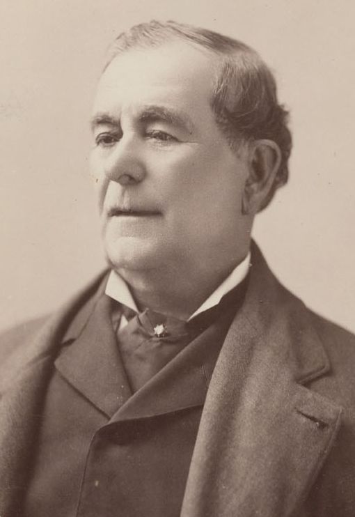
Mariano Vallejo, ca. 1880–85, founder and city namesake
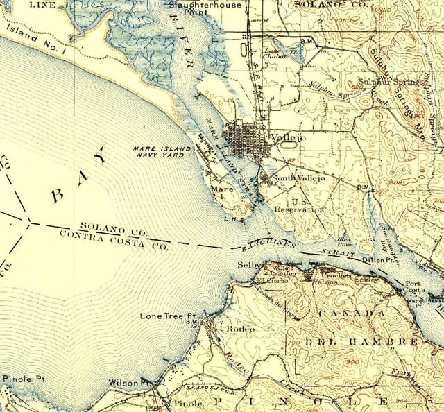
Vallejo region in 1902
Vallejo was once home of the Coastal Miwok as well as Suisunes and other Patwin Native American tribes. The Columbus Parkway EIR documents three confirmed Native American sites located in the rock outcrops in the hills above Blue Rock Springs Park. The California Archaeological Inventory has indicated that the three Indian sites are located on Sulphur Springs Mountain.
The city of Vallejo was once part of the 84,000-acre (340 km2) Rancho Suscol Mexican land grant of 1843 by Governor Manuel Micheltorena to General Mariano Guadalupe Vallejo. The city was named after this Mexican military officer and title holder who was appointed in settling and overseeing the north bay region. General Vallejo was responsible for military peace in the region and founded the pueblo of Sonoma in 1836. In 1846 independence-minded Anglo immigrants rose up against the Mexican government of California in what would be known as the Bear Flag Revolt which resulted in his imprisonment in Sutter's Fort. This was subsequently followed by the annexation of the California Republic to the United States. General Vallejo, though a Mexican army officer, generally acquiesced in the annexation of California to the United States, recognizing the greater resources of the United States and benefits that would bring to California. He was a proponent of reconciliation and statehood after the Bear Flag Revolt, and has a U.S. Navy submarine, the USS Mariano G. Vallejo (SSBN-658), named after him.
In 1850, Vallejo proposed plans for a new city, to be called Eureka, with the capitol, university, botanical garden and other features. After a statewide referendum, his proposal was accepted, although a new name was decided upon: Vallejo. In 1851, a commission appointed by the Senate found a site on a hill that overlooked the bay and could see San Francisco on a clear day, and it was approved for its symbolic strategic value. In 1851, Vallejo was the official state capitol, with the government prepared to meet for the first time the following year. In 1852, the legislature convened for the first time. Unfortunately, Vallejo didn't follow through with building a capitol for them to meet in. After being forced to meet in a leaky building, sitting on barrels, they motioned to move sessions to Sacramento, and served there for the remainder of the session after only 11 days. In 1853, it was again the meeting place for the legislature, solely for the purpose of moving the capitol officially to Benicia, which occurred on February 4, 1853, after only a month. Benicia is named after Vallejo's wife, Francisca Benicia Carrillo. After legislature left, the government established a naval shipyard on Mare Island, which helped the town overcome the loss. Due to the presence of the shipyard, Filipinos began to immigrate to Vallejo beginning in the first decades of the 20th century.[25] The yard functioned for over a hundred years, finally closing in 1996.[26]
The U.S. government appointed the influential Vallejo as Indian agent for Northern California. He also served on the state constitutional convention in 1849. Afterward, Vallejo remained active in state politics, but challenges to his land titles around Sonoma eventually left him impoverished and reduced his ranch from 250,000 acres to a mere 300. He eventually retired from public life, questioning the wisdom of his having welcomed the American acquisition of California in the first place. Vallejo died in 1890, a symbol of the eclipse of Californio wealth, power, and prestige.[27]
Although the town is named after General Vallejo, the man regarded as the true founder of Vallejo is John B. Frisbie. After his daughter Epifania married Frisbie, General Vallejo granted him power of attorney for the land grant. It was Frisbie who hired E.H. Rowe, the man who designed the city layout and who named the east-west streets after states and the north-south streets after California counties.[28]
In the early 1900s, Vallejo was home to a Class D minor-league baseball team, referred to in local newspapers sometimes as the "Giants" and other times simply as "The Vallejos." Pacific Coast League star and future Chicago White Sox center fielder Ping Bodie played for Vallejo during the 1908 season, in which the team reached the California state title game. The team was disbanded in the early 1920s. Today it is home to the Vallejo Admirals of the independent Pacific Association.
Downtown Vallejo retains many of its historic Victorian and Craftsman homes.
Notable events
Zodiac Killer
The Zodiac Killer was a serial killer who was active in Northern California during the 1960s. He claimed to have killed 37, but the actual number is unknown. Three of the murders attributed to the Zodiac Killer took place within the city limits or nearby. Both the Vallejo Police Department and San Francisco Police Department investigated the murders but were never able to solve the case. The case was marked inactive in April 2004 but was reopened in March 2007. The Vallejo Police Department website has a menu tab for providing Zodiac Crime Tips. The case also remains open in additional jurisdictions.
LGBT Community
As early as the 1940s and before, Vallejo is known to have had a well-formed gay community, which was a short drive or boat ride away from San Francisco.[29] At one time Vallejo boasted eight gay bars. After a migration of gays and lesbians from San Francisco in the decade 2000–2009,[30] openly gay members of the community encountered what they described as a backlash against them. The school district was threatened by the ACLU to be sued for harassment of a 17-year-old lesbian by school administrators. The school settled the lawsuit with the student. The school agreed to pay her $25,000, adopt a more stringent non-discrimination policy and include a curriculum that positively portrayed gay and lesbian people.[31]
Two openly gay men have been elected to Vallejo's city council.
Artist migration
In recent years, Vallejo has attracted a large community of artists to the region in search of lower rent and larger work-spaces.[32] Artists pushed out of larger Bay Area cities like San Francisco and Oakland have been working with city leaders to revitalize the once blighted downtown area. The artist-run Vallejo Art Walk scheduled on the second Friday of every month in downtown Vallejo has been recognized as a hub for artists in the Bay Area and the entirety of California.[33]
November 2007 mayoral election
The incumbent mayor was former city council member Anthony Intintoli; Florence Douglas was the first female mayor in Vallejo.
Bankruptcy
On May 6, 2008, the City Council voted 7–0 to file for Chapter 9 bankruptcy, at the time becoming the largest California city to do so.[34][35] Stephanie Gomes, Vallejo City Councilwoman, largely blames exorbitant salaries and benefits for Vallejo firefighters and police officers. Reportedly, salaries and benefits for public safety workers account for at least 80 percent of Vallejo's general fund budget. (Stockton filed for bankruptcy in June 2012.)
On November 1, 2011, a federal judge released Vallejo from bankruptcy after nearly three years.[36] The city is now taking measures to find more revenue, and has already gotten new employee contracts, lowered pension plans for firefighters, increased the amount city staffers add to their health insurance and eliminated minimum staffing requirements for the fire department. The legal fees included in bankruptcy cost the city $8 million.
A brief analysis of Vallejo's financial downfall is featured in Michael Lewis' book Boomerang: Travels in the New Third World.[37]
Participatory budgeting
On April 17, 2012, the City Council approved the first citywide participatory budgeting (PB) process in the United States. The Council allocated $3.4 million to the Vallejo PB process and since then, Vallejo residents and business and property owners have been developing and designing project ideas. They have vetted and reduced more than 800 project ideas to 36 projects that will be on the ballot. Vallejo residents 14 years of age and older will vote and choose six out of 36 projects to vote on from May 11 through May 18, 2013.
The second cycle of participatory budgeting in Vallejo was initiated on February 4, 2014, with $2.4 million allocated. A public vote open to all residents of Vallejo age 16 and over took place in October 2014.
Economy
According to the City's 2009 Comprehensive Annual Financial Report,[38] the top employers in the city are:
| Employer | of Employees | |
|---|---|---|
| 1 | Kaiser Permanente Medical Center | 3,906 |
| 2 | Six Flags Discovery Kingdom | 1,600 |
| 3 | Vallejo City Unified School District | 1,600 |
| 4 | Kaiser Permanente Call Center | 950 |
| 5 | Sutter Health Medical Center | 690 |
| 6 | City of Vallejo | 574 |
| 7 | Sutter Health | 400 |
| 8 | Touro University California | 385 |
| 9 | United States Forest Service | 300 |
| 10 | Petrochem | 225 |
Schools
Public high schools
Vallejo High School
Jesse Bethel High School
John Finney High School
MIT Academy High School
Public middle schools
Francisco Solano Middle School
Benjamin Franklin Middle School
Hogan Middle School (formerly Hogan High School and Springstowne Middle School)
Vallejo Charter School
Mare Island Technology Academy Middle School
Griffin Academy Middle School
Private and parochial schools
Alternative schools
Community Day School
Vallejo Regional Education Center (formerly Vallejo Adult School)
HOPE School
Aspire 2 Achieve School
Post-secondary education
California Maritime Academy (part of the CSU system)
Solano Community College – Vallejo
Touro University California
Other places of interest
Golf courses
Blue Rock Springs East and West Golf Course (36 holes, public)
Hiddenbrooke Golf Course (18 holes, public)
Mare Island Golf Course (18 holes, public)
Museums and attractions
McCune Rare Book and Art Collection
Solano County Fairgrounds (near I-80 and Hwy 37)
Six Flags Discovery Kingdom (previously Six Flags Marine World)
Mare Island Naval Shipyard and Mare Island Historic Park
Vallejo Naval and Historical Museum
Empress Theater
Vallejo Vinyl & Pinball [66]
Mcree Goudeau Center
Coalshed Studios, Arts Collective, http://coalshedstudios.com/ [67]
Sailing and boating
Vallejo Yacht Club[42]
Vallejo Municipal Marina
Glen Cove Marina
Local events
Farmers' Market – every Saturday in Downtown Georgia Street
Vallejo Symphony [43]
Northern California Pirate Festival
Mocktoberfest, Punk & Edge Arts Festival
Obtanium Works, Obtanium Cup
Open Studios
First Saturday Bands at the Hub
2nd Friday Art Walk
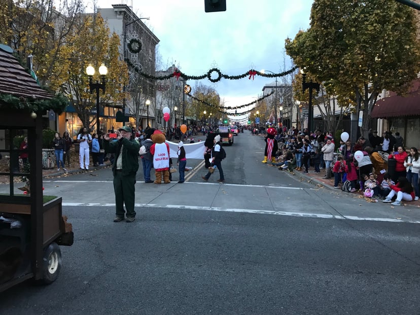
July 4 Parade & Red, White, and Blues Groove Festival & Fireworks
Mad Hatter Holiday Festival, Parade, and Tree Lighting
Waterfront Weekend
Pista Sa Nayon
Carnevale Fantastico!
Juneteenth Celebration
Unity Day Celebration
Vallejo Shakespeare in the Park
Government
The Government of Vallejo is defined under the Charter of the City of Vallejo. It is a council–manager government and consists of the Mayor, City Council, and numerous departments and officers under the supervision of the City Manager, such as the Vallejo Police Department, Vallejo Fire Department, Vallejo Public Works Department, and Vallejo Economic Development Department.
As of June 2019, the council consists of:
Bob Sampayan (mayor),
Pippen Dew (vice mayor),
Robert H. McConnell,
Hakeem Brown,
Katy Miessner,
Hermie Sunga, and
Rozanna Verder-Aliga.[2]
County, state, and federal representation
Residents of Vallejo participate in the Government of Solano County and elections for Solano County Board of Supervisors districts 1 and 2 as well as the Sheriff-Coroner, District Attorney, Assessor/Recorder, Auditor-Controller and Treasurer/Tax Collector/County Clerk. As of January 2013, these were represented by Supervisors Erin Hannigan and Linda Seifert, Sheriff-Coroner Thomas Ferrara, District Attorney Krishna Abrams, Assessor/Recorder Marc Tonnesen, Auditor-Controller Phyllis Taynton, and Treasurer/Tax Collector/County Clerk Charles Lomeli.
In the California State Legislature, Vallejo is in the 3rd Senate District, represented by Democrat Bill Dodd, and in the 14th Assembly District, represented by Democrat Tim Grayson.[44]
In the United States House of Representatives, it's in California's 5th congressional district, represented by Democrat Mike Thompson.[45]
Notable people
Larry Asera, businessman
Monique Alexander, porn star
April Bowlby, actress
Raymond Burr, actor
Raphael Cruz, acrobat and actor
Rockmond Dunbar, actor
Lodena Edgecumbe, dancer, dance educator
Cleven "Goodie" Goudeau, award-winning art director/cartoonist
Wesley Mann, actor
Ed Rollins, political advisor
Zodiac Killer, serial killer
Athletes
C. J. Anderson, National Football League player
Brandon Armstrong, National Basketball Association player
Dick Bass, National Football League player
Jahvid Best, National Football League player
Jabari Bird, pro basketball player
Ping Bodie, Major League Baseball player
Bobby Brooks, Major League Baseball player
Bill Buckner, Major League Baseball player
Willie Calhoun, professional baseball player
Tyler Cravy, Major League Baseball Player
Joey Chestnut, competitive eater
Natalie Coughlin, swimmer with 12 Olympic medals
Ward Cuff, National Football League player
Thomas DeCoud, National Football League player
Mike Felder, Major League Baseball player
Augie Garrido, University of Texas baseball coach
Jeff Gordon, NASCAR 4-time champion, 5-time Brickyard 400 winner, 3-time Daytona 500 winner
Damon Hollins, Major League Baseball player
Fulton Kuykendall, National Football League player
Tony Longmire, Major League Baseball player
Tug McGraw, Major League Baseball player
Mike Merriweather, National Football League player
Mark Muñoz, Ultimate Fighting Championship fighter
DeMarcus Nelson, National Basketball Association player
Rashad Ross, National Football League player
CC Sabathia, Major League Baseball player
Sammie Stroughter, National Football League player
Joe Taufete'e, player for USA Rugby
Barton Williams, Olympian track and field
Musicians
B-Legit
Baby Bash
Celly Cel
Con Funk Shun
DJ D-Wrek
Droop-E
E-40
Emcee Lynx
Funky Aztecs
H.E.R.
Johnny Otis
J-Diggs
Khayree
Little Bruce
Mac Dre
Mac Mall
The Mossie
N2Deep
Nef the Pharaoh
One Vo1ce
Paul Foster
Reek Daddy
Roy Rogers
Sleep Dank
Sly Stone
SOB X RBE
Suga-T
The Click
Turf Talk
Young Lay
Dubee
Media
Sister cities
Vallejo has six sister cities:[49]
| City | Division | Country | Year of Partnership |
|---|---|---|---|
| Trondheim | Trøndelag | 1960 | |
| Akashi | 1968 | ||
| La Spezia | 1987 | ||
| Baguio | directly administered | 1993 | |
| Bagamoyo | Pwani Region | 1993 | |
| Jincheon | North Chungcheong Province | 2001 |
See also
List of cities and towns in California
List of cities and towns in the San Francisco Bay Area