Hawaiian Islands
Hawaiian Islands
| Native name: Mokupuni o Hawai‘i | |
|---|---|
 The Windward Islands | |
| Geography | |
| Location | North Pacific Ocean |
| Total islands | 137 |
| Highest point |
|
| Administration | |
United States | |
| State | Hawaii |
| Largest settlement | Honolulu |
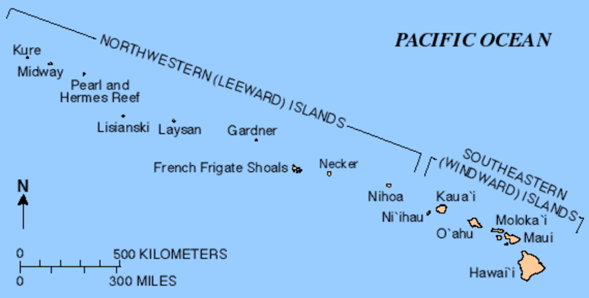
The Hawaiian Islands (Hawaiian: Mokupuni o Hawai‘i) are an archipelago of eight major islands, several atolls, numerous smaller islets, and seamounts in the North Pacific Ocean, extending some 1,500 miles (2,400 kilometers) from the island of Hawaiʻi in the south to northernmost Kure Atoll. Formerly the group was known to Europeans and Americans as the Sandwich Islands, a name chosen by James Cook in honor of the then First Lord of the Admiralty John Montagu, 4th Earl of Sandwich. The contemporary name is derived from the name of the largest island, Hawaii Island.
Although Hawaii is now a U.S. state, it is only a part of the U.S. politically and not geographically connected to North America. The state of Hawaii occupies the archipelago almost in its entirety (including the uninhabited Northwestern Hawaiian Islands), with the sole exception of Midway Island, which instead separately belongs to the United States as one of its unincorporated territories within the United States Minor Outlying Islands.
The Hawaiian Islands are the exposed peaks of a great undersea mountain range known as the Hawaiian–Emperor seamount chain, formed by volcanic activity over a hotspot in the Earth's mantle. The islands are about 1,860 miles (3,000 km) from the nearest continent.[1]
| Native name: Mokupuni o Hawai‘i | |
|---|---|
The Windward Islands | |
| Geography | |
| Location | North Pacific Ocean |
| Total islands | 137 |
| Highest point |
|
| Administration | |
United States | |
| State | Hawaii |
| Largest settlement | Honolulu |
Islands and reefs
Captain James Cook visited the islands on January 18, 1778,[2] and named them the "Sandwich Islands" in honor of John Montagu, 4th Earl of Sandwich, who was one of his sponsors as the First Lord of the Admiralty.[3] This name was in use until the 1840s, when the local name "Hawaii" gradually began to take precedence.[4]
The Hawaiian Islands have a total land area of 6,423.4 square miles (16,636.5 km2). Except for Midway, which is an unincorporated territory of the United States, these islands and islets are administered as Hawaii—the 50th state of the United States.[5]
Main islands
| Island | Nickname | Area | Population (as of 2010) | Density | Highest point | Elevation | Age (Ma)[6] | Location |
|---|---|---|---|---|---|---|---|---|
| Hawaiʻi[7] | The Big Island | 4,028.0 sq mi (10,432.5 km2) | 185,079 | 45.948/sq mi (17.7407/km2) | Mauna Kea | 13,796 ft (4,205 m) | 0.4 | 19°34′N 155°30′W [40] |
| Maui[8] | The Valley Isle | 727.2 sq mi (1,883.4 km2) | 144,444 | 198.630/sq mi (76.692/km2) | Haleakalā | 10,023 ft (3,055 m) | 1.3–0.8 | 20°48′N 156°20′W [41] |
| Oʻahu[9] | The Gathering Place | 596.7 sq mi (1,545.4 km2) | 953,207 | 1,597.46/sq mi (616.78/km2) | Mount Kaʻala | 4,003 ft (1,220 m) | 3.7–2.6 | 21°28′N 157°59′W [42] |
| Kauaʻi[10] | The Garden Isle | 552.3 sq mi (1,430.5 km2) | 66,921 | 121.168/sq mi (46.783/km2) | Kawaikini | 5,243 ft (1,598 m) | 5.1 | 22°05′N 159°30′W [43] |
| Molokaʻi[11] | The Friendly Isle | 260.0 sq mi (673.4 km2) | 7,345 | 28.250/sq mi (10.9074/km2) | Kamakou | 4,961 ft (1,512 m) | 1.9–1.8 | 21°08′N 157°02′W [44] |
| Lānaʻi[12] | The Pineapple Isle | 140.5 sq mi (363.9 km2) | 3,135 | 22.313/sq mi (8.615/km2) | Lānaʻihale | 3,366 ft (1,026 m) | 1.3 | 20°50′N 156°56′W [45] |
| Niʻihau[13] | The Forbidden Isle | 69.5 sq mi (180.0 km2) | 170 | 2.45/sq mi (0.944/km2) | Mount Pānīʻau | 1,250 ft (381 m) | 4.9 | 21°54′N 160°10′W [46] |
| Kahoʻolawe[14] | The Target Isle | 44.6 sq mi (115.5 km2) | 0 | 0/sq mi (0/km2) | Puʻu Moaulanui | 1,483 ft (452 m) | 1.0 | 20°33′N 156°36′W [47] |
The eight main islands of Hawaii (also called the Hawaiian Windward Islands) are listed here. All except Kahoolawe are inhabited.[15]
Smaller islands, atolls, reefs
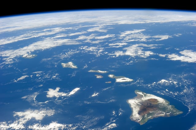
Hawaiian Islands from space.[16]
Smaller islands, atolls, and reefs (all west of Niʻihau are uninhabited) form the Northwestern Hawaiian Islands, or Hawaiian Leeward Islands:
Nihoa (Mokumana)
Necker (Mokumanamana)
French Frigate Shoals (Kānemilohaʻi)
Gardner Pinnacles (Pūhāhonu)
Maro Reef (Nalukākala)
Laysan (Kauō)
Lisianski Island (Papaʻāpoho)
Pearl and Hermes Atoll (Holoikauaua)
Midway Atoll (Pihemanu)
Kure Atoll (Mokupāpapa)
Islets
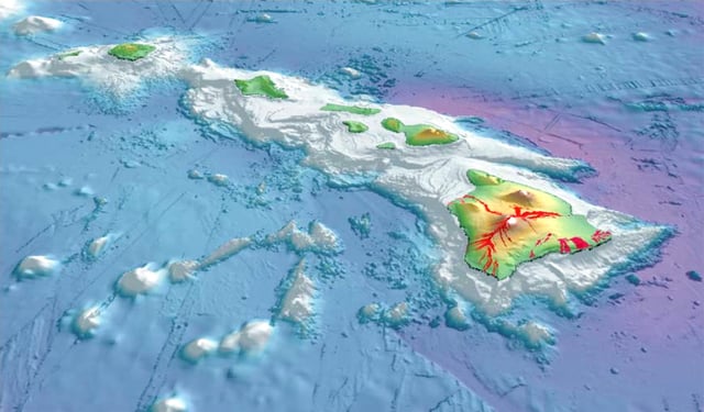
3-D perspective view of the southeastern Hawaiian Islands, with the white summits of Mauna Loa (4,170 m or 13,680 ft high) and Mauna Kea (4,206 m or 13,799 ft high). The islands are the tops of massive volcanoes, the bulk of which lie below the sea surface. Ocean depths are colored from violet (5,750 m or 18,860 ft deep northeast of Maui) and indigo to light gray (shallowest). Historical lava flows are shown in red, erupting from the summits and rift zones of Mauna Loa, Kilauea, and Hualalai volcanoes on Hawaiʻi.
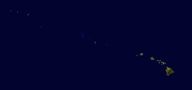
A composite satellite image from NASA of the Hawaiian Islands taken from outer space. Click on the image for a larger view that shows the main islands and the extended archipelago.
The state of Hawaii counts 137 "islands" in the Hawaiian chain.[17] This number includes all minor islands and islets, or very small islands, offshore of the main islands (listed above) and individual islets in each atoll. These are just a few:
Ford Island (Mokuʻumeʻume)
Lehua
Ka'ula
Kaohikaipu
Mānana
Mōkōlea Rock
Nā Mokulua
Molokini
Mokoliʻi
Moku Manu
Moku Ola (Coconut Island, Hawaii)
Moku o Loʻe (Coconut Island, Oahu)
Sand Island
Grass Island
Geology
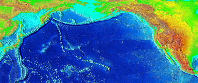
Eruptions from the Hawaii hotspot left a trail of underwater mountains across the Pacific over millions of years, called the Emperor Seamounts
This chain of islands, or archipelago, developed as the Pacific Plate moved slowly northwestward over a hotspot in the Earth's mantle at a rate of approximately 32 miles (51 km) per million years. Thus, the southeast island is volcanically active, whereas the islands on the northwest end of the archipelago are older and typically smaller, due to longer exposure to erosion. The age of the archipelago has been estimated using potassium-argon dating methods.[18] From this study and others,[19][20] it is estimated that the northwesternmost island, Kure Atoll, is the oldest at approximately 28 million years (Ma); while the southeasternmost island, Hawaiʻi, is approximately 0.4 Ma (400,000 years). The only active volcanism in the last 200 years has been on the southeastern island, Hawaiʻi, and on the submerged but growing volcano to the extreme southeast, Loʻihi. The Hawaiian Volcano Observatory of the USGS documents recent volcanic activity and provides images and interpretations of the volcanism. Kīlauea has been erupting nearly continuously since 1983.
Almost all of the magma of the hotspot has the composition of basalt, and so the Hawaiian volcanoes are composed almost entirely of this igneous rock. There is very little coarser-grained gabbro and diabase. Nephelinite is exposed on the islands but is extremely rare. The majority of eruptions in Hawaiʻi are Hawaiian-type eruptions because basaltic magma is relatively fluid compared with magmas typically involved in more explosive eruptions, such as the andesitic magmas that produce some of the spectacular and dangerous eruptions around the margins of the Pacific basin.
Hawaiʻi island (the Big Island) is the biggest and youngest island in the chain, built from five volcanoes. Mauna Loa, taking up over half of the Big Island, is the largest shield volcano on the Earth. The measurement from sea level to summit is more than 2.5 miles (4 km), from sea level to sea floor about 3.1 miles (5 km).[21].
Earthquakes
The Hawaiian Islands have many earthquakes, generally caused by volcanic activity. Most of the early earthquake monitoring took place in Hilo, by missionaries Titus Coan, Sarah J. Lyman and her family. From 1833 to 1896, approximately 4 or 5 earthquakes were reported per year.[22]
On October 15, 2006, there was an earthquake with a magnitude of 6.7 off the northwest coast of the island of Hawaii, near the Kona area of the big island. The initial earthquake was followed approximately five minutes later by a magnitude 5.7 aftershock. Minor-to-moderate damage was reported on most of the Big Island. Several major roadways became impassable from rock slides, and effects were felt as far away as Honolulu, Oahu, nearly 150 miles (240 km) from the epicenter. Power outages lasted for several hours to days. Several water mains ruptured. No deaths or life-threatening injuries were reported.
On May 4, 2018 there was a 6.9 earthquake in the zone of volcanic activity from Kīlauea.
Earthquakes are monitored by the Hawaiian Volcano Observatory run by the USGS.
Tsunamis
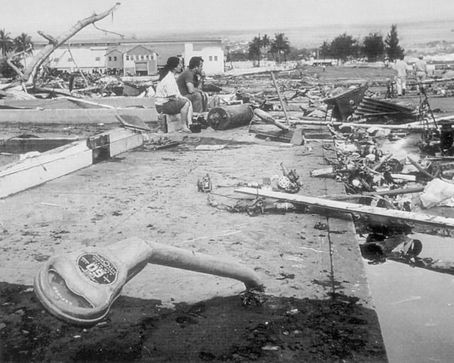
Aftermath of the 1960 Chilean tsunami in Hilo, Hawaiʻi, where the tsunami left 61 people dead and 282 seriously injured. The waves reached 35 feet (11 m) high.
The Hawaiian Islands are subject to tsunamis, great waves that strike the shore. Tsunamis are most often caused by earthquakes somewhere in the Pacific. The waves produced by the earthquakes travel at speeds of 400–500 miles per hour (600–800 km/h) and can affect coastal regions thousands of miles (kilometers) away.
Tsunamis may also originate from the Hawaiian Islands. Explosive volcanic activity can cause tsunamis. The island of Molokaʻi had a catastrophic collapse or debris avalanche over a million years ago; this underwater landslide likely caused tsunamis. The Hilina Slump on the island of Hawaiʻi is another potential place for a large landslide and resulting tsunami.
The city of Hilo on the Big Island has been most affected by tsunamis, where the in-rushing water is accentuated by the shape of Hilo Bay. Coastal cities have tsunami warning sirens.
A tsunami resulting from an earthquake in Chile hit the islands on February 27, 2010. It was relatively minor, but local emergency management officials utilized the latest technology and ordered evacuations in preparation for a possible major event. The Governor declared it a "good drill" for the next major event.
A tsunami resulting from an earthquake in Japan hit the islands on March 11, 2011. It was relatively minor, but local officials ordered evacuations in preparation for a possible major event. The tsunami caused about $30.1 million in damages.[24]
Ecology
The islands are home to many endemic species. Since human settlement, first by Polynesians, non native trees, plants, and animals were introduced. These included species such as rats and pigs, that have preyed on native birds and invertebrates that initially evolved in the absence of such predators. The growing population of humans has also led to deforestation, forest degradation, treeless grasslands, and environmental degradation. As a result, many species which depended on forest habitats and food became extinct--with many current species facing extinction. As humans cleared land for farming, monocultural crop production replaced multi-species systems.
The arrival of the Europeans had a more significant impact, with the promotion of large-scale single-species export agriculture and livestock grazing. This led to increased clearing of forests, and the development of towns, adding many more species to the list of extinct animals of the Hawaiian Islands. As of 2009, many of the remaining endemic species are considered endangered.[25]
National Monument
On June 15, 2006, President George W. Bush issued a public proclamation creating Papahānaumokuākea Marine National Monument under the Antiquities Act of 1906. The Monument encompasses the northwestern Hawaiian Islands and surrounding waters, forming the largest[26] marine wildlife reserve in the world. In August 2010, UNESCO's World Heritage Committee added Papahānaumokuākea to its list of World Heritage Sites.[27][28][29] On August 26, 2016, President Barack Obama greatly expanded Papahānaumokuākea, quadrupling it from its original size.[30][31][32]
Climate
The climate of the Hawaiian Islands is tropical but it experiences many different climates, depending on altitude and weather.[33] The islands receive most rainfall from the trade winds on their north and east flanks (the windward side) as a result of orographic precipitation.[33] Coastal areas in general and especially the south and west flanks or leeward sides, tend to be drier.[33]
See also
Hawaii Inter-Island Cable System
Index of Hawaii-related articles
List of birds of Hawaii
List of fish of Hawaii
List of mountain peaks of Hawaii
List of Ultras of Hawaii
Maritime fur trade
Outline of Hawaii