United States Virgin Islands

United States Virgin Islands
Virgin Islands of the United States | |
|---|---|
Unincorporated and organized U.S. territory | |
Flag  Seal | |
| Motto(s): "United in Pride and Hope" | |
| Anthem: "Virgin Islands March" | |
.svg) Location of the United States Virgin Islands | |
| Sovereign state | United States |
| Before purchase | Danish West Indies |
| Transfer from Denmark | March 31, 1917 |
| Capital and largest city | Charlotte Amalie 18°21′N 64°56′W [110] |
| Official languages | English |
| Ethnic groups (2010) | 76.0% Black 15.7% White 2.1% Multiracial 1.4% Asian 4.9% other |
| Demonym(s) | Virgin Islander |
| Government | Devolved presidential constitutional dependency |
• Governor | Albert Bryan (D) |
• Lt. Governor | Tregenza Roach (D) |
• U.S. House Delegate | Stacey Plaskett (D) |
| Legislature | Legislature of the Virgin Islands |
| Area | |
• Total | 133.73 km2(51.63 sq mi) (168th) |
• Water (%) | negligible |
| Highest elevation | 1,555 ft (474 m) |
| Population | |
• 2010 census | 106,405[1] |
• Density | 297/km2(769.2/sq mi) |
| GDP(PPP) | 2015 estimate |
• Total | $4.58 billion |
• Per capita | $36,350[2] |
| HDI(2008) | very high · 59th |
| Currency | United States dollar (US$) (USD) |
| Time zone | UTC-4:00 (AST) |
| USPS abbreviation | VI |
| Trad. abbreviation | U.S.V.I. |
| Date format | mm/dd/yyyy |
| Driving side | left |
| Calling code | +1-340 |
| ISO 3166 code |
|
| Internet TLD | .vi |
The United States Virgin Islands (abbreviated USVI; also called the US Virgin Islands or American Virgin Islands), officially the Virgin Islands of the United States, is a group of islands in the Caribbean and an unincorporated and organized territory of the United States.[3] The islands are geographically part of the Virgin Islands archipelago and are located in the Leeward Islands of the Lesser Antilles to the east of Puerto Rico and west of the British Virgin Islands.[4]
Previously known as the Danish West Indies of the Kingdom of Denmark–Norway, they were sold to the United States by Denmark in the Treaty of the Danish West Indies of 1917.[3] They are classified by the United Nations as a Non-Self-Governing Territory, and are currently an organised, unincorporated United States territory. The U.S. Virgin Islands are organised under the 1954 Revised Organic Act of the Virgin Islands and have since held five constitutional conventions.
Virgin Islands of the United States | |
|---|---|
Unincorporated and organized U.S. territory | |
Flag Seal | |
| Motto(s): "United in Pride and Hope" | |
| Anthem: "Virgin Islands March" | |
Location of the United States Virgin Islands | |
| Sovereign state | United States |
| Before purchase | Danish West Indies |
| Transfer from Denmark | March 31, 1917 |
| Capital and largest city | Charlotte Amalie 18°21′N 64°56′W [110] |
| Official languages | English |
| Ethnic groups (2010) | 76.0% Black 15.7% White 2.1% Multiracial 1.4% Asian 4.9% other |
| Demonym(s) | Virgin Islander |
| Government | Devolved presidential constitutional dependency |
• Governor | Albert Bryan (D) |
• Lt. Governor | Tregenza Roach (D) |
• U.S. House Delegate | Stacey Plaskett (D) |
| Legislature | Legislature of the Virgin Islands |
| Area | |
• Total | 133.73 km2(51.63 sq mi) (168th) |
• Water (%) | negligible |
| Highest elevation | 1,555 ft (474 m) |
| Population | |
• 2010 census | 106,405[1] |
• Density | 297/km2(769.2/sq mi) |
| GDP(PPP) | 2015 estimate |
• Total | $4.58 billion |
• Per capita | $36,350[2] |
| HDI(2008) | very high · 59th |
| Currency | United States dollar (US$) (USD) |
| Time zone | UTC-4:00 (AST) |
| USPS abbreviation | VI |
| Trad. abbreviation | U.S.V.I. |
| Date format | mm/dd/yyyy |
| Driving side | left |
| Calling code | +1-340 |
| ISO 3166 code |
|
| Internet TLD | .vi |
Etymology
The islands were named "Santa Úrsula y las Once Mil Vírgenes" by Christopher Columbus in 1493 after the legend of Saint Ursula and the 11,000 virgins.[3] The name was later shortened to "the Virgin Islands."[3]
History
Pre-colonial era
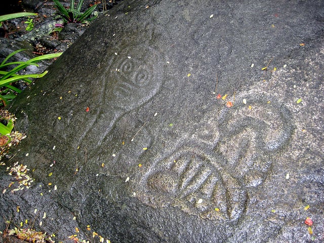
Arrival of Europeans
Christopher Columbus, on his second voyage in 1493, is thought to have been the first European to see the islands, giving them their current name.[4] The Spanish later settled in 1555, with English and French settlers arriving on St Croix from 1625.[4] There followed a complex period in which the islands were disputed between Spain, France, Britain and also the Netherlands.[4]
Danish period
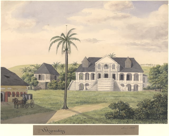
The Høgensborg estate on Sankt Croix, 1833
Denmark also took an interest in the islands, and the Danish West India Company settled on St. Thomas in 1672 and St. John in 1694, later purchasing St. Croix from France in 1733.[6] The islands became royal Danish colonies in 1754, named the Danish West Indian Islands (Danish: De dansk-vestindiske øer). The islands proved ideal for sugar plantations - sugarcane, produced by slaves forcibly shipped in from Africa, drove the islands' economy during the 18th and early 19th centuries.[4] Other plantation crops included cotton and indigo dye.[7] During the 17th-18th centuries a sizeable Jewish community also began to settle on the islands.[8]
In 1733, St. John was the site of one of the first significant slave rebellions in the New World when Akan-Akwamu slaves from the Gold Coast (modern Ghana) took over the island for six months. The Danish were able to defeat the enslaved Africans with help from the French in Martinique.[9] Instead of allowing themselves to be recaptured, more than a dozen of the ringleaders shot themselves before the French forces could capture them. It is estimated that by 1775 slaves outnumbered the Danish settlers by a ratio of 5:1.
With the plantations no longer as profitable, Danish settlers began to abandon their estates, causing a significant drop in population and the overall economy. Additionally, the 1867 hurricane and earthquake and tsunami further impacted the economy. For the remainder of the period of Danish rule the islands were not economically viable and significant transfers had to be made from the Danish state budget to the authorities in the islands.
The United States began to take an interest in the islands, and in 1867 a treaty to sell St. Thomas and St. John to the US was agreed but never effected.[14] A number of reforms aimed at reviving the islands' economy were attempted, but none had great success. A second draft treaty to sell the islands to the United States was negotiated in 1902 but was defeated in the upper house of the Danish parliament in a tie vote (because the opposition carried a 97-year-old life member into the chamber).[14]
The onset of the First World War brought the reform period to a close and again left the islands isolated. During the submarine warfare phases of the war the United States, fearing that the islands might be seized by Germany as a submarine base, again approached Denmark about buying them. After a few months of negotiations, a selling price of $25 million[4] in United States gold coin was agreed, equivalent to $575.61 million in 2018 dollars. At the same time the economics of continued possession weighed heavily on the minds of Danish decision makers, and a consensus in favor of selling emerged in the Danish parliament.
The[Treaty of the Danish West Indies was signed in August 1916,[15] with a referendum on the sale held in Denmark in December 1916 in which voters approved the decision to sell. The deal was finalized on January 17, 1917, when the United States and Denmark exchanged their respective treaty ratifications. The United States took possession of the islands on March 31, 1917 and the territory was renamed the 'Virgin Islands of the United States.' Every year Transfer Day is recognized as a holiday, to commemorate the acquisition of the islands by the United States.[16]
American period
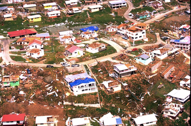
The aftermath of Hurricane Marilyn on the island of St. Thomas, 1995. In recent decades the US Virgin Islands have been devastated by a series of hurricanes
US citizenship was granted to many inhabitants of the islands in 1927 and 1932. The US dollar was adopted in the territory in 1934[17] and from 1935 to 1939 the islands were a part of the United States customs area.[18] The 1936 Organic Act and the 1954 Revised Organic Act established the local government.[4] In 1970 Virgin Islanders elected their first governor, Melvin H. Evans, and from 1976 the islands began work on creating their own constitution.[4] Tourism began to develop, over time becoming the most important sector of the Islands' economy.[4]
Water Island, a small island to the south of St. Thomas, was initially administered by the US federal government and did not become a part of the United States Virgin Islands territory until 1996, when 50 acres (20 ha) of land was transferred to the territorial government. The remaining 200 acres (81 ha) of the island were purchased from the United States Department of the Interior in May 2005 for $10, a transaction that marked the official change in jurisdiction.[19]
In 1966 Hess Oil began construction on an oil refinery. Until February 2012, the Hovensa plant located on St. Croix was one of the world's largest petroleum refineries, refining 494,000 bbl/d (78,500 m3/d), and contributed about 20% of the territory's GDP. The refinery ceased operation in 2012, and the facility stopped exporting petroleum products in 2014. In the final year of full refinery operations, the value of exported petroleum products was $12.7 billion (2011 fiscal year).[20] Since refining ended, the 34-million-barrel tank farm has operated as a crude oil and petrochemical storage facility for third-party customers. The refinery's closure provoked a local economic crisis.[21][22] Following the acquisition of the 1,500-acre complex by ArcLight Capital Partners, LLC, in 2016, Limetree Bay Ventures, LLC, was formed, and is currently executing a project to refurbish and restart the refinery, with a processing capability of up to 200,000 bbl/d (32,000 m3/d).[23][24]
Hurricane Hugo struck the U.S. Virgin Islands in 1989, causing catastrophic physical and economic damage, particularly on the island of St. Croix. The territory was again struck by Hurricane Marilyn in 1995, killing eight people and causing more than $2 billion in damage. The islands were again struck by Hurricanes Bertha, Georges, Lenny, and Omar in 1996, 1998, 1999, and 2008, respectively, but damage was not as severe in those storms.
In September 2017, Category 5 Hurricane Irma caused catastrophic damage, particularly to St. John and St. Thomas. Just two weeks later, Category 5 Hurricane Maria's weaker outer eyewall crossed St. Croix. Sustained winds at the Sandy Point National Wildlife Refuge on St. Croix reached 99 to 104 mph (159 to 167 km/h) and gusted to 137 mph (220 km/h).[25] Weather stations on St. Croix recorded 5 and 10 inches of rain from the hurricane, and estimates for St. John and St. Thomas were somewhat less.[26] The hurricane killed two people, both in their homes: one person drowned and another was trapped by a mudslide.[27] A third person had a fatal heart attack during the hurricane.[28] The hurricane caused extensive and severe damage to St. Croix. After both hurricanes, the office of V.I. congresswoman Stacey Plaskett stated that 90% of buildings in the Virgin Islands were damaged or destroyed and 13,000 of those buildings had lost their roofs.[29] The Luis Hospital suffered roof damage and flooding, but remained operational.[30]
Geography
A map of the United States Virgin Islands
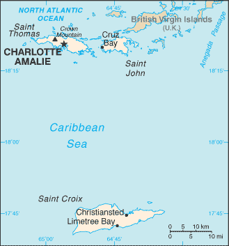
The U.S. Virgin Islands are in the Atlantic Ocean, about 40 miles (64 km) east of Puerto Rico and immediately west of the British Virgin Islands. They share the Virgin Islands Archipelago with the Puerto Rican Virgin Islands of Vieques and Culebra (administered by Puerto Rico), and the British Virgin Islands.
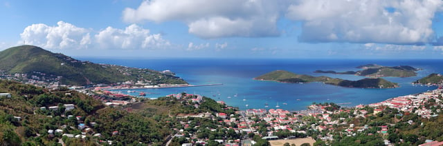
The territory consists of three main islands: St. Thomas, St. John, and St. Croix, as well as several dozen smaller islands.[31] The main islands have nicknames often used by locals: "Twin City" (St. Croix), "Rock City" (St. Thomas), and "Love City" (St. John).[32] The combined land area of the islands is roughly twice the size of Washington, D.C.
The U.S. Virgin Islands are known for their white sand beaches, including Magens Bay and Trunk Bay, and deepwater harbors along the Anegada Passage, including Charlotte Amalie (the capital) and Christiansted.[33] Like most Caribbean islands, the islands of the Virgin Islands, including St. Thomas, are volcanic in origin and hilly. The highest point is Crown Mountain on St. Thomas at 1,555 feet (474 m).[31][4]
St. Croix, the largest of the U.S. Virgin Islands, lies to the south and has a flatter terrain due to being coral in origin. The National Park Service manages more than half of St. John, nearly all of Hassel Island, and many acres of coral reef.
There are several national parks, such as the Virgin Islands National Park, Virgin Islands Coral Reef National Monument, Buck Island Reef National Monument, Christiansted National Historic Site, and Salt River Bay National Historical Park and Ecological Preserve.
The U.S. Virgin Islands lie on the boundary of the North American plate and the Caribbean Plate. Natural hazards include earthquakes and hurricanes.[31]
Climate
The United States Virgin Islands enjoy a tropical climate, with little seasonal change throughout the year.[31] Rainfall is concentrated in the high sun period (May through October), while in the winter the northeast trade winds prevail. Summer and winter high temperatures differ by 5 °F (3 °C) or less on average.
| Climate data for St. Thomas, Virgin Islands | |||||||||||||
|---|---|---|---|---|---|---|---|---|---|---|---|---|---|
| Month | Jan | Feb | Mar | Apr | May | Jun | Jul | Aug | Sep | Oct | Nov | Dec | Year |
| Record high °F (°C) | 93 (34) | 93 (34) | 94 (34) | 96 (36) | 97 (36) | 99 (37) | 98 (37) | 99 (37) | 98 (37) | 97 (36) | 95 (35) | 92 (33) | 99 (37) |
| Average high °F (°C) | 85 (29) | 85 (29) | 86 (30) | 87 (31) | 88 (31) | 89 (32) | 90 (32) | 90 (32) | 90 (32) | 89 (32) | 87 (31) | 86 (30) | 88 (31) |
| Average low °F (°C) | 72 (22) | 73 (23) | 73 (23) | 74 (23) | 76 (24) | 78 (26) | 78 (26) | 78 (26) | 78 (26) | 77 (25) | 75 (24) | 74 (23) | 76 (24) |
| Record low °F (°C) | 63 (17) | 62 (17) | 56 (13) | 62 (17) | 66 (19) | 67 (19) | 57 (14) | 59 (15) | 64 (18) | 66 (19) | 52 (11) | 62 (17) | 52 (11) |
| Average precipitation inches (mm) | 2.38 (60) | 1.48 (38) | 1.42 (36) | 2.74 (70) | 3.06 (78) | 2.53 (64) | 2.85 (72) | 3.74 (95) | 5.58 (142) | 5.42 (138) | 5.23 (133) | 2.96 (75) | 39.39 (1,001) |
| Source: weather.com[34] | |||||||||||||
Politics and government
Charlotte Amalie, St. Thomas, the Islands' capital
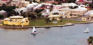
Christiansted, the largest town on Saint Croix
The U.S. Virgin Islands are an organized, unincorporated United States territory.[35] Although they are US citizens, US Virgin Islanders residing in the territory are ineligible to vote for the president of the United States. They are, however, eligible to vote if they become residents of a state. People born in the U.S. Virgin Islands derive their US citizenship from congressional statute.[36]
The US Democratic and Republican parties allow U.S. Virgin Islands citizens to vote in their presidential primary elections for delegates to the respective national conventions.[37] The main political parties in the U.S. Virgin Islands themselves are the Democratic Party of the Virgin Islands, the Independent Citizens Movement, and the Republican Party of the Virgin Islands. Additional candidates run as independents.
At the national level, the U.S. Virgin Islands elect a delegate to Congress from their at-large congressional district. The elected delegate, while able to vote in committee, cannot participate in floor votes. The current House of Representatives delegate is Stacey Plaskett, a Democrat. Like other territories, the U.S. Virgin Islands does not have U.S. Senators.[38]
At the territorial level, fifteen senators – seven from the district of St. Croix, seven from the district of St. Thomas and St. John, and one senator at-large who must be a resident of St. John – are elected for two-year terms to the unicameral Virgin Islands Legislature. There is no limit as to the number of terms they can serve.[39]
The U.S. Virgin Islands have elected a territorial governor every four years since 1970. Previous governors were appointed by the president of the United States.
Legal system
The U.S. Virgin Islands have a District Court, Superior Court and the Supreme Court.[35] The District Court is responsible for federal law, while the Superior Court is responsible for U.S. Virgin Islands law at the trial level and the Supreme Court is responsible for appeals from the Superior Court for all appeals filed on or after January 29, 2007. Appeals filed prior to that date are heard by the Appellate Division of the District Court. Appeals from the federal District Court are heard by the United States Court of Appeals for the Third Circuit, located in Philadelphia, Pennsylvania. District Court judges are appointed by the US president, while Superior Court and Supreme Court judges are appointed by the governor.
Constitution
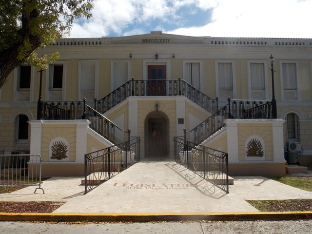
The Legislature Building in Charlotte Amalie
On October 21, 1976, President Gerald Ford signed Pub.L. 94–584 [111] authorizing the people of the United States Virgin Islands to organize a government pursuant to a constitution, which would be automatically approved if Congress did not act within 60 days.
In 2004, the 25th Legislature of the Virgin Islands established the Fifth Constitutional Convention, a constitutional convention gathered in order to draft a new constitution. On May 26, 2009 the U.S. Virgin Islands Fifth Constitutional Convention adopted a proposed Constitution of the Virgin Islands, which was submitted by President Barack Obama to Congress on March 1, 2010. However, in June 2009, Governor John de Jongh, Jr. had rejected the resulting constitutional draft, saying the terms of the document would "violate federal law, fail to defer to federal sovereignty and disregard basic civil rights."[40] A lawsuit filed by members of the Convention to force Governor de Jongh to forward the document to President Barack Obama was ultimately successful. The President of the United States forwarded the proposal to Congress—which then had 60 days to approve or reject the document—in May 2010, along with a report noting concerns raised by the United States Department of Justice and restating the issues noted by Governor de Jongh. A US Congressional resolution disapproving of the proposed constitution and requesting that the Fifth Constitutional Convention reconvene to consider changes to address these issues was signed into law (Pub.L. 111–194 [112] ) by President Obama on June 30, 2010.[41][42]
Months later, a federal lawsuit was filed in the Federal District Court of the Virgin Islands in 2011. The lawsuit claimed that the United States had to provide US Virgin Islanders with the ability to be represented in Congress and vote for US President. The case is Civil No. 3:11-cv-110, Charles v. U.S. Federal Elections Commission et al. (3:11-cv-00110-AET-RM). It alleged that racial discrimination present in an all-white and segregated US Congress of 1917 was the impetus to deny the right to vote to a majority non-white constituency. The case was ultimately dismissed and closed on August 16, 2012 by District Judge Anne E. Thompson from the Federal District Court of the Virgin Islands, Division of St. Croix.[43]
As of early 2017, the territory still did not have its own constitution. Little has been achieved on this front since 2009 when a proposed constitution was contested by the US Justice Department on the grounds that the powers sought exceeded what would be considered allowable under territorial status.[46] In September 2012, the Fifth Constitutional Convention of the U.S. Virgin Islands was unable to come to a decision on the contents of a proposed constitution by the October 31 deadline.[47][48]
Administrative divisions
Administratively, the U.S. Virgin Islands are divided into two (2) districts: the Saint Thomas & Saint John district, and the Saint Croix district.[49][50][51] However, the U.S. Census Bureau divides each of the 3 main islands into 3 separate statistical entities (which are further divided into twenty (20) sub-districts).[52] Below is the U.S. Census Bureau's division model.
| Districts | St. Thomas | St. John | St. Croix |
|---|---|---|---|
| Sub-districts |
|
|
|
While a Danish possession, the Islands were divided into "quarters" (five on St. John and nine on St. Croix) which were further divided into many dozens of "estates". Estate names are still used to write addresses; estates and quarters are used in describing real estate, especially on St. John[55] and St. Croix.[56] More densely populated towns such as Frederiksted and Christiansted on St. Croix were historically referred to as "districts", in contrast to the surrounding plantation land.
Self-determination
A 1993 referendum on status attracted only 31.4% turnout, and so its results (in favor of the status quo) were considered void. No further referenda have been scheduled since.
In 2016, the United Nations's Special Committee on Decolonisation recommended to the UN's General Assembly that this larger body should assist in "decolonization" and help the people of the territory to "determine freely their future political status". Specifically, the Special Committee recommended that the "views of the people of the United States Virgin Islands in respect of their right to self-determination should be ascertained" and that the UN should "actively pursue a public awareness campaign aimed at assisting the people of the United States Virgin Islands with their inalienable right to self-determination and in gaining a better understanding of the options for self-determination".[57]
Governors of the U.S. Virgin Islands
Law enforcement
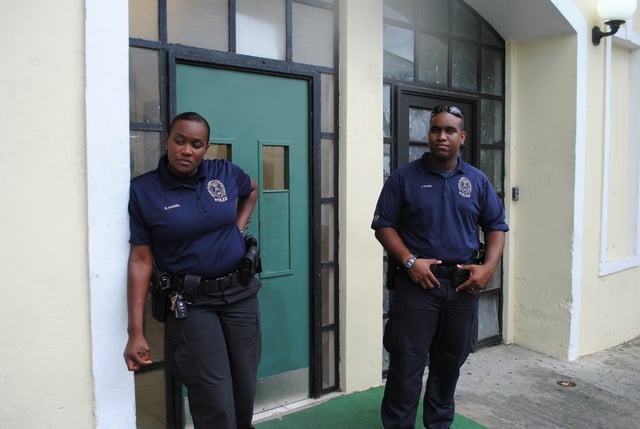
USVI police officers in 2012
Law enforcement services are provided by the United States Virgin Islands Police Department (USVIPD).
Military
Defence is the responsibility of the United States.[3] There are some military facilities and personnel on the islands, supported by the US government:
United States Army Reserve
Virgin Islands Army National Guard Virgin Islands Air National Guard — stationed at St Croix ANGS Virgin Islands Army National Guard — stationed at St Croix ANGS Lionel A. Jackson Readiness Center — shared facility for Army and Air units
Although a public airport, Henry E. Rohlsen Airport has serviced aircraft from the United States Air Force, as well as the United States Army.
Economy
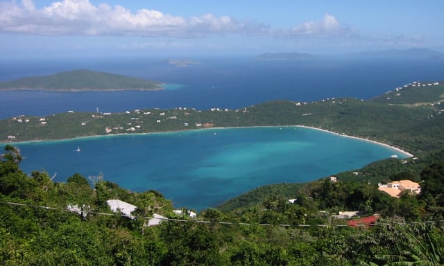
Magens Bay, St. Thomas
A 2012 Economic report from the US Census Bureau indicated a total of 2,414 business establishments generating $6.8 billion in sales, employing 32,465 people and paying $1.1 billion in payroll per year. Between 2007 and 2012, sales declined by $12.6 billion, or 64.9 percent. (In 2007, total sales were $19.5 billion and the number employed was 35,300.)[59]
According to a report on the first half of 2016 by the VI Bureau of Economic Research, the unemployment rate was 11.5 percent. In May 2016 the islands' Bureau of Economic Research indicated that there were 37,613 non-agricultural wage and salary jobs in the islands. This report states that the "leisure and hospitality sector" employed an average of 7,333 people. The retail trade sector, which also serves many tourists, averaged another 5,913 jobs. Other categories which also include some tourism jobs include Arts and Entertainment (792 jobs), Accommodation and Food (6,541 jobs), Accommodation (3755 jobs), Food Services and Drink (2,766 jobs). A large percentage of the 37,613 non-farm workers are employed in dealing with tourists. Serving the local population is also part of the role of these sectors.[20]
In a May 2016 report, some 11,000 people were categorised as being involved in some aspect of agriculture in the first half of 2016, but this category makes up a small part of the total economy. At that time, there were approximately 607 manufacturing jobs and 1,487 natural resource and construction jobs. The single largest employer was the government.[20] In mid-February 2017, the USVI was facing a financial crisis due to a very high debt level of $2 billion and a structural budget deficit of $110 million.[60][61] In August 2017, the U.S. Virgin Islands government was rejected from the bond market.
Personal income
The median income for a household in the territory was $24,704, and the median income for a family was $28,553 according to the 2010 Census. Males had a median income of $28,309 versus $22,601 for females. The per capita income for the territory was $13,139. The average private sector salary was $34,088 and the average public sector salary was $52,572.[20] About 28.7% of families and 32.5% of the population were below the poverty line, including 41.7% of those less than 18 years old and 29.8% of those 65 or more years old. Nearly 70% of adults had at least a high school diploma and 19.2% had a bachelor's degree or higher.[62]
Financial challenges
Analysts reviewing the economy often point to the closure of the HOVENSA oil refinery, the islands’ largest private sector employer, in early 2012 as having a major negative impact on the territory's economy. In late 2013 the Reserve Bank of New York's Research and Statistics Group pointed out that manufacturing employment dropped by 50% in May 2012, and by another 4% by November 2012, and that the GDP fell by 13%, "mainly due to an 80% drop-off in exports (mostly refined petroleum)". On the other hand, tourism and some other service industries were growing. As well, the 2010 census indicated that a relatively high share of the adult population is in the labor force: 66%, versus 65% on the mainland and well below 50% in Puerto Rico. The bottom line in this report however is that "it may also be worthwhile to look at the physical infrastructure and human capital built up over the years, with an eye toward using it for other types of productive economic activity".[63]
A May 2016 report by Bloomberg expressed concern about the islands' tax-supported debt load.[64] By January 23, 2017 this had increased to $2 billion. That translated to a per capita debt of $19,000, which was higher than the per capita debt in Puerto Rico which was undergoing a severe financial crisis at the time. A Debtwire analyst writing in Forbes indicated that nothing short of a miracle would prevent a financial collapse.[60] Another area of concern was the structural budget deficit which was at $110 million in mid February 2017.[65] The government instituted a new law in March 2017 with new or increased taxes on rum, beer, tobacco products and sugary drinks, as well as internet purchases and timeshare unit owners.[66]
Tourism
Tourism, trade, and other service-oriented industries are the primary economic activities, accounting for nearly 60% of the GDP. Approximately 2.5 million tourists per year visit, most arriving on cruise ships.[20] Such visitors do not spend large amounts of money ($146.70 each on average) but as a group, they contributed $339.8 million to the economy in 2012.[67]
However, the travel industry warned in late 2014 that work needs to be done for USVI tourism practices to meet 21st century demands. "The needs of the community and the tourists may be diametrically opposed; however, for tourism to flourish cooperation is a necessity. From reduced energy costs to increased educational opportunities, from improved healthcare to a continued reduction in crime, these and many other challenges must be tackled."[67]
Additionally, the islands frequently are a starting point for private yacht charters to the neighboring British Virgin Islands. Euromonitor indicates that over 50% of the workforce is employed in some tourism-related work.[68]
Other sectors
The manufacturing sector consists of mainly rum distilling. The agricultural sector is small, with most food being imported. International business and financial services are a small but growing component of the economy. Most energy is also generated from imported oil, leading to electricity costs four to five times higher than the U.S. mainland.[69] The Virgin Islands were the highest oil consumers per capita in the world in 2007.[70] The Virgin Islands Water and Power Authority[71] also uses imported energy to operate its desalination facilities to provide fresh water.
Government
The CIA World Factbook lists the value of federal programs and grants — $241.4 million in 2013, 19.7% of the territory's total revenues — and that "the economy remains relatively diversified. Along with the tourist industry, it appears that rum exports, trade, and services will be major income sources in future years".[72]
Tax and trade
The U.S. Virgin Islands are an independent customs territory from the mainland United States and operate largely as a free port. US citizens thus do not have to clear customs when arriving in the U.S. Virgin Islands, but do when traveling to the mainland. Local residents are not subject to US federal income taxes on U.S. Virgin Islands source income; they pay taxes to the territory equal to what their federal taxes would be if they lived in a state.[73]
Transport and communications
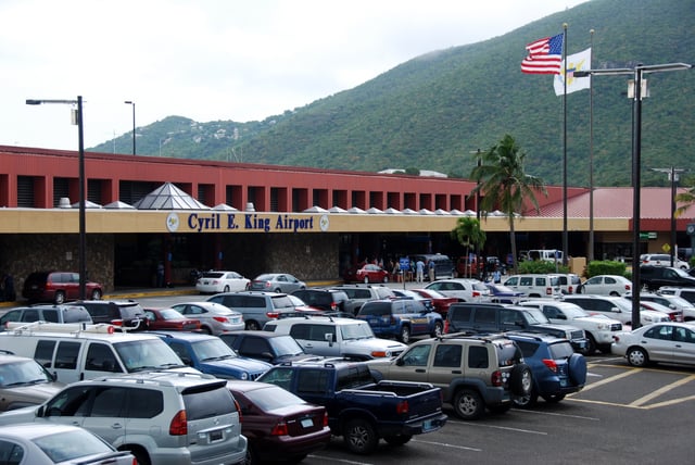
Cyril E. King Airport on St Thomas
The Henry E. Rohlsen International Airport serves St. Croix and the Cyril E. King International Airport serves St. Thomas and St. John.
The U.S. Virgin Islands is the only US jurisdiction that drives on the left. This was inherited from what was then-current practice on the islands at the time of the 1917 transfer of the territory to the United States from Denmark. However, because most cars in the territory are imported from the mainland United States, the cars in the territory are left-hand drive. Traffic signals are located on the opposite side of the road, and many standard road signs have been altered to fit the left-side driving.
As in other US territories, U.S. Virgin Islands mail service is handled by the United States Postal Service, using the two-character state code "VI" for domestic mail delivery.[74][75][76] ZIP codes are in the 008xx range.[76] As of January 2010, specifically assigned codes include 00801–00805 (St Thomas),[77] 00820–00824 (Christiansted),[78] 00830–00831 (St. John),[79] 00840–00841 (Frederiksted),[80] and 00850–00851 (Kingshill).[81] The islands are part of the North American Numbering Plan, using area code 340, and island residents and visitors are able to call most toll-free US numbers.[74]
The U.S. Virgin Islands are located in the Atlantic Standard Time zone and do not participate in daylight saving time. When the mainland United States is on Standard Time, the U.S. Virgin Islands are one hour ahead of Eastern Standard Time. When the mainland United States is on daylight saving time, Eastern Daylight Time is the same as Atlantic Standard Time.
Demographics
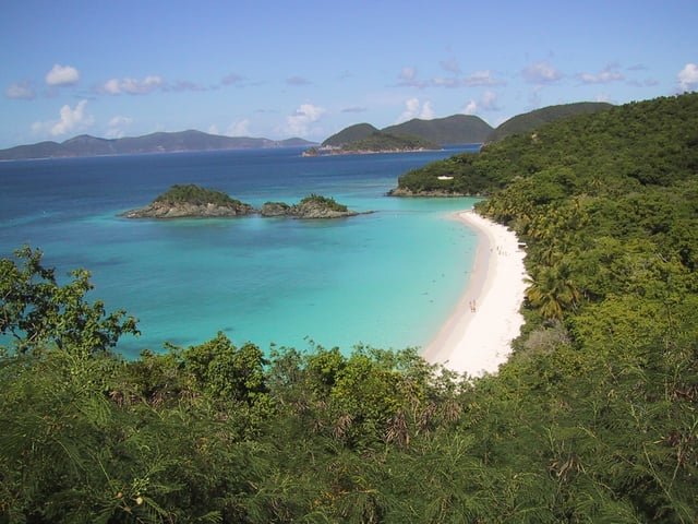
Trunk Bay, St. John
| Historical population | ||
|---|---|---|
| Year | Pop. | ±% |
| 1970 | 62,468 | — |
| 1980 | 96,569 | +54.6% |
| 1990 | 101,809 | +5.4% |
| 2000 | 108,612 | +6.7% |
| 2010 | 106,405 | −2.0% |
In 2010 there were 40,648 households out of which 34.7% had children under the age of 18 living with them, 33.2% were married couples living together, 24.9% had a female householder with no husband present, and 34.5% were non-families. 30.2% of all households were made up of individuals and 6.3% had someone living alone who was 65 years of age or older. The average household size was 2.64 and the average family size was 3.34.
In the territory, the population in 2010 was distributed with 31.6% under the age of 18, 8.0% from 18 to 24, 27.1% from 25 to 44, 24.9% from 45 to 64, and 8.4% who were 65 years of age or older. The median age was 33 years. For every 100 females, there were 91.4 males. For every 100 females ages 18 and up, there were 87.7 males. The annual population growth is −0.12%.
The literacy rate for the adult population was 94.9% in 2010.[84]
Ethnic groups
The racial makeup of the U.S. Virgin Islands was:[85]
Black or Afro-Caribbean: 76.0% (66.1% Non-Hispanic Black)
White: 15.7% (13.5% Non-Hispanic Whites)
Asian: 1.4%
Mixed: 2.1%
Other: 4.5%
Hispanic or Latino of any race: 17.4% (10.3% Puerto Rican, 5.4% Dominican)
Many residents can trace their ancestry to other Caribbean islands, especially Puerto Rico and the Lesser Antilles. The territory is largely Afro-Caribbean in origin.[3]
Languages
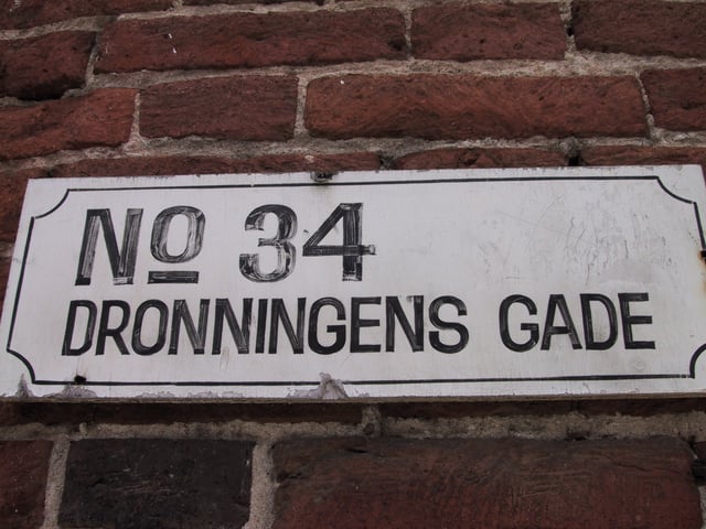
A Danish street name in Charlotte-Amalie
English is currently the dominant language. Spanish is spoken by about 17% of the population, and other languages are spoken by 11% of the population.[86] English has been the predominant language since 1917 when the islands were transferred from Denmark to the United States. Under Danish rule, the official language was Danish, but it was solely the language of administration and spoken by Danes, a tiny minority of the overall population that primarily occupied administrative roles in colonial Danish West Indian society. However, place names and surnames of Denmark-Norway origin are still commonly found throughout the islands.
Although the U.S. Virgin Islands was a Danish possession during most of its colonial history, Danish never was a spoken language among the populace, black or non-Danish white, as the majority of plantation and slave owners were of Dutch, English, Scottish, Irish, or Spanish descent.[87] Even during Danish ownership, Dutch, another Germanic language like Danish, was more common, at least during some of those 245 years, specifically on St. Thomas and St. John. In St. Croix, English was the dominant language. St. Croix was owned by the French until 1733 when the island was sold to the Danish West Indian and Guinea Company. By 1741 there were five times as many English on the island as Danes. English Creole emerged on St. Croix more so than Dutch Creole, which was more popular on St. Thomas and St. John. Other languages spoken in the Danish West Indies included Irish, Scots, Spanish, and French, as well as Virgin Islands English Creole.[88]
Virgin Islands Creole English, an English-based creole locally known as "dialect", is spoken in informal situations. The form of Virgin Islands Creole spoken on St. Croix, known as Crucian, is slightly different from that spoken on St. Thomas and St. John. Because the U.S. Virgin Islands are home to thousands of immigrants from across the Caribbean, Spanish and various French creole languages are also widely spoken.
Religion
Owing to both their Danish past and American present, Protestantism on the islands has long been widespread. It was first introduced when Lutheranism was brought to the islands in the Danish colonization. The Danish crown also allowed other religious traditions on the islands including Anglicanism, Roman Catholicism, the Moravian Church and other Protestant groups.[92] Historically, St. Thomas and St. Croix are known for missionary efforts undertaken by the Moravian missionaries. They were allowed on the islands by the Danish royal court, but came under scrutiny when they denounced slavery.[92][93] A number of neo-Protestant traditions including Pentecostalism, various evangelical Protestants and the Seventh-day Adventists arrived later with the switch of allegiance from Denmark to the United States.
There is also a strong Roman Catholic presence. Rastafari is also prevalent. St. Thomas is home to one of the oldest Jewish communities in the Western Hemisphere as Sephardi Jews began to settle the island in the 18th century as traders and merchants. The St. Thomas Synagogue in Charlotte Amalie is the second oldest synagogue on American soil and oldest in terms of continuous usage.[94]
Health
In 2010, the national average life expectancy was 79.61 years. It was 76.57 years for men and 82.83 for women.[84]
Education
The United States Virgin Islands Department of Education serves as the territory's education agency, and has two school districts: St. Thomas-St. John School District and St. Croix School District.[95]
The University of the Virgin Islands provides higher education leading to associate's, bachelor's, and master's degrees, with campuses on St. Thomas and St. Croix.
Culture
The culture of the Virgin Islands reflects the various people that have inhabited the present-day U.S. Virgin Islands and British Virgin Islands, which despite their political separation having kept close cultural ties. The culture derives chiefly from West African, European and American traditions, in addition to the influences from the immigrants from the Arab world, India and other Caribbean islands. The islands were strongly influenced by the Dutch,[96] French and Danish during the long periods the islands were under these powers.
Music
Media
The islands have a number of AM and FM radio stations (mostly on St. Thomas and St. Croix) broadcasting music, religious, and news programming. (See List of radio stations in US Territories.) Full and low-power television stations are split between St. Thomas and St. Croix. (See List of television stations in the U.S. Virgin Islands.) Newspapers include:
The Avis, printed daily on St. Croix.
The Virgin Islands Daily News,[97] printed daily on St. Thomas.
St. John Tradewinds,[98] distributed weekly on St. John.
St. Thomas – St. John This Week,[99] online only.
St. Thomas Source,[100] online only.
St. Croix Source,[101] online only.
St. John On Island Times,[102] news and information on St. John, USVI.
Public holidays
January 1: New Year's Day
January 6: Three Kings Day
January (third Monday): Martin Luther King, Jr. Day
February (third Monday): Presidents' Day
March 31: Transfer Day (celebrates the transfer of the islands from Denmark to the US)
March - April: Holy Thursday, Good Friday, Easter Monday
May (fourth Monday): Memorial Day
July 3: Emancipation Day
July 4: US Independence Day
September (first Monday): Labor Day
October (second Monday): Virgin Islands Puerto Rico Friendship Day/Columbus Day
November 1: D. Hamilton Jackson Day (also known as "Liberty Day", or "Bull and Bread Day")
November 11: Veterans Day
November (fourth Thursday): Thanksgiving Day
December 25: Christmas
December 26: Christmas Second Day (also known as "Boxing Day")
Virgin Islands government employees are also given administrative leave for St. Croix carnival events in January and St. Thomas carnival events in April/May.
See also
Outline of the United States Virgin Islands
Index of United States Virgin Islands-related articles
Bibliography of the United States Virgin Islands