Everipedia Logo
Everipedia is now IQ.wiki - Join the IQ Brainlist and our Discord for early access to editing on the new platform and to participate in the beta testing.
Rosario Islands

Rosario Islands

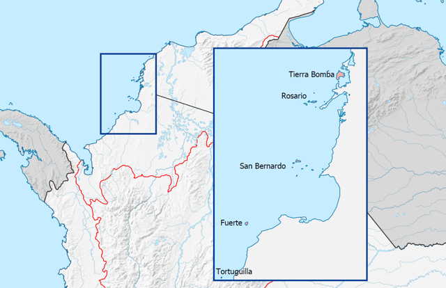
Location map of the Rosario islands

Location map of the Rosario islands

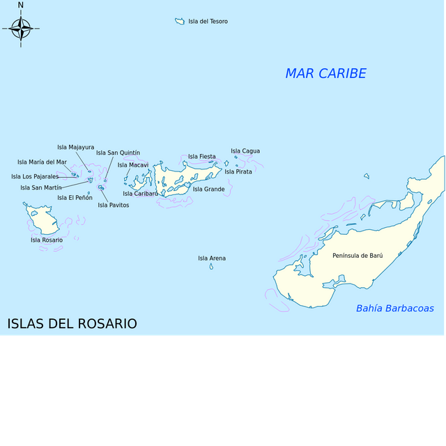
The Islas del Rosario (Rosario Islands), also referred to as Corales Islas del Rosario (Coral Islands of Rosario),[1] is an archipelago located off the coast of Colombia, approximately 100 kilometres (62 miles) from Cartagena.[2] It is one of the 46 Natural National Parks of Colombia. The national park was founded in 1988,[1] to protect one of the most important coral reefs of the Colombian Caribbean coast. People can visit the national park area of the islands, and tours are available.[3] Isla Rosario has an aquarium and open-sea oceanarium (oceanario) that people can visit.[4][5] Activities include swimming, snorkeling[6] and fishing, among others.

Rosario Islands
Rosario Islands is located in Islas del Rosario
Rosario Islands
Rosario Islands
Rosario Islands is located in Colombia
Rosario Islands
Rosario Islands
Rosario Islands is located in Caribbean
Rosario Islands
Rosario Islands
Geography
Coordinates10°10′30″N 75°45′00″W [8]
ArchipelagoArchipelago of San Bernardo
Administration
**Colombia**

Geography and geology

The park has an area of 120,000 square kilometres (46,332 square miles), from the line of the highest tide to the beryl of the 50 metres (164 feet) of depth, it extends from the underwater platform and the coral reefs west from the Island of Baru, the reefs of the archipelagos of Nuestra Señora del Rosario and San Bernardo and the underwater platform in between, as well as the Tesoro, Rosario, Mucura, and Maravilla islands.

Characteristics

This area was declared a Natural National Park due to the necessity to preserve and protect the coral reefs and the associated ecosystems, such as the sea grass and mangroves, and the numerous species of seaweed and animals that inhabit them.

Coral reef formation is "...enhanced on the windward side of the islands" due to wave action and water qualities that encourage coral growth.

History

In 1885, the area was described as "extremely dangerous to approach" by boat.[7]

See also

  • Caribbean region of Colombia

  • Insular region of Colombia

  • List of islands of South America

References

[1]
Citation Linkbooks.google.comSmall Islands: Issues and Actions. United Nations Department of Public Information. 1999. pp. 59–62.
Sep 26, 2019, 8:11 AM
[2]
Citation Linkbooks.google.comEncyclopedia of the World's Coastal Landforms. Springer Science & Business Media. p. 259. ISBN 978-1-4020-8638-0.
Sep 26, 2019, 8:11 AM
[3]
Citation Linkbooks.google.comWoods, S. (2012). Bradt Colombia. Bradt Guides (in Dutch). Bradt Travel Guides. p. 82. ISBN 978-1-84162-364-1.
Sep 26, 2019, 8:11 AM
[4]
Citation Link2backpackers.comSchmidt, Chelsea (March 26, 2013). "Colombia Travel – The Rosario Islands". 2backpackers.com/. Retrieved 10 March 2015.
Sep 26, 2019, 8:11 AM
[5]
Citation Linkbooks.google.comGriest, S.E. (2007). 100 Places Every Woman Should Go. 100 Places Series. Travelers' Tales. p. 168. ISBN 978-1-932361-47-6.
Sep 26, 2019, 8:11 AM
[6]
Citation Linkbooks.google.comBurns, Robert H. (September 1996). Yachting. p. 34. ISSN 0043-9940
Sep 26, 2019, 8:11 AM
[7]
Citation Linkbooks.google.comGreen, F.M. (1885). The Navigation of the Caribbean Sea and Gulf of Mexico: The coast of the mainland, from Cape Orange ... to the Rio Grande del Norte ... with the adjacent islands, cays and banks. Comp. by Lieut. W. W. Gillpatrick. H. O. pub. U.S. Government Printing Office. p. 159.
Sep 26, 2019, 8:11 AM
[8]
Citation Linktools.wmflabs.org10°10′30″N 75°45′00″W
Sep 26, 2019, 8:11 AM
[9]
Citation Linkbooks.google.comSmall Islands: Issues and Actions
Sep 26, 2019, 8:11 AM
[10]
Citation Linkbooks.google.comEncyclopedia of the World's Coastal Landforms
Sep 26, 2019, 8:11 AM
[11]
Citation Linkbooks.google.comBradt Colombia
Sep 26, 2019, 8:11 AM
[12]
Citation Link2backpackers.com"Colombia Travel – The Rosario Islands"
Sep 26, 2019, 8:11 AM
[13]
Citation Linkbooks.google.com100 Places Every Woman Should Go
Sep 26, 2019, 8:11 AM
[14]
Citation Linkbooks.google.comYachting
Sep 26, 2019, 8:11 AM
[15]
Citation Linkbooks.google.comThe Navigation of the Caribbean Sea and Gulf of Mexico: The coast of the mainland, from Cape Orange ... to the Rio Grande del Norte ... with the adjacent islands, cays and banks. Comp. by Lieut. W. W. Gillpatrick
Sep 26, 2019, 8:11 AM
[16]
Citation Linken.wikipedia.orgThe original version of this page is from Wikipedia, you can edit the page right here on Everipedia.Text is available under the Creative Commons Attribution-ShareAlike License.Additional terms may apply.See everipedia.org/everipedia-termsfor further details.Images/media credited individually (click the icon for details).
Sep 26, 2019, 8:11 AM