Okinawa Prefecture

Okinawa Prefecture
| Japanese transcription(s) | |
|---|---|
| •Japanese | |
| •Rōmaji | Okinawa-ken |
| Coordinates: | |
| Country | Japan |
| Region | Kyushu |
| Island | Okinawa,DaitōandSakishima |
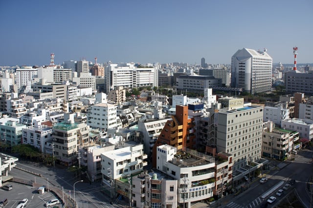
| Capital | Naha |
| Subdivisions | : 5,Municipalities: 41 |
| Government | |
| •Governor | Denny Tamaki |
| Area | |
| • Total | 2,280.98 km (880.69 sq mi) |
| Area rank | 44th |
| Population | |
| • Total | 1,451,965 |
| • Rank | 27th |
| • Density | 640/km (1,600/sq mi) |
| ISO 3166 code | JP-47 |
| Website | |
| Symbols | |
| Bird | Okinawa woodpecker(Sapheopipo noguchii) |
| Fish | Banana fish(Pterocaesio diagramma, "takasago", "gurukun") |
| Flower | Deego (Erythrina variegata |
| Tree | Pinus luchuensis |
| Prehistoric | |
| Early Shell Mound | |
| Middle Shell Mound | |
| Late Shell Mound | 750–1187 |
| Gusuku | 1187–1314 |
| Sanzan | 1314–1429 |
| First Shō Dynasty | 1429–1469 |
| Second Shō Dynasty | 1469–1879 |
| Meiji | 1879–1912 |
| Taishō | 1912–1926 |
| Pre-World War 2 | 1926–1945 |
| American Occupation | 1945–1972 |
| Okinawa Prefecture | 1972– |
| Invasion of Ryūkyū | 1609 |
| Ryūkyū Domain | 1872–1879 |
| Annexation of Ryūkyū | 1879 |
| Militarism | |
| Battle of Okinawa | 1945 |
| Koza riot | 1970 |
| Kagoshima Prefecture | 1953– |
| Ryukyu Kingdom | |
| Ryukyu independence movement | |
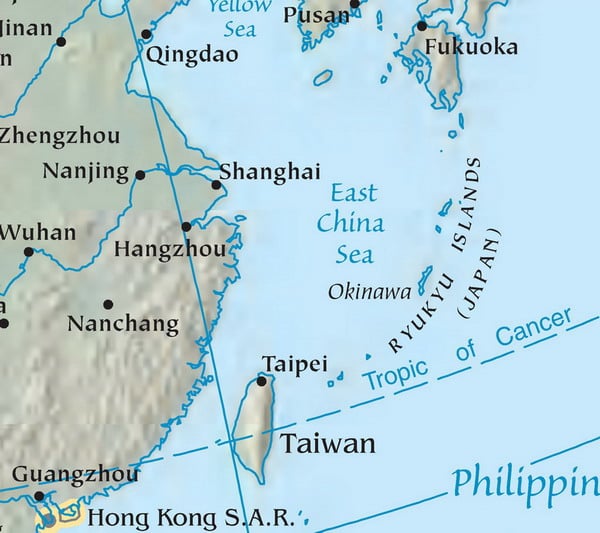
Okinawa Prefecture (Japanese: 沖縄県, Hepburn: Okinawa-ken, Okinawan: ウチナー Uchinaa) is the southernmost prefecture of Japan.[6] It encompasses two thirds of the Ryukyu Islands in a chain over 1,000 kilometres (620 mi) long. The Ryukyu Islands extend southwest from Kagoshima Prefecture on Kyushu (the southwesternmost of Japan's four main islands) to Taiwan. Naha, Okinawa's capital, is located in the southern part of Okinawa Island.[7]
| Japanese transcription(s) | |
|---|---|
| •Japanese | |
| •Rōmaji | Okinawa-ken |
| Coordinates: | |
| Country | Japan |
| Region | Kyushu |
| Island | Okinawa,DaitōandSakishima |
| Capital | Naha |
| Subdivisions | : 5,Municipalities: 41 |
| Government | |
| •Governor | Denny Tamaki |
| Area | |
| • Total | 2,280.98 km (880.69 sq mi) |
| Area rank | 44th |
| Population | |
| • Total | 1,451,965 |
| • Rank | 27th |
| • Density | 640/km (1,600/sq mi) |
| ISO 3166 code | JP-47 |
| Website | |
| Symbols | |
| Bird | Okinawa woodpecker(Sapheopipo noguchii) |
| Fish | Banana fish(Pterocaesio diagramma, "takasago", "gurukun") |
| Flower | Deego (Erythrina variegata |
| Tree | Pinus luchuensis |
| Prehistoric | |
| Early Shell Mound | |
| Middle Shell Mound | |
| Late Shell Mound | 750–1187 |
| Gusuku | 1187–1314 |
| Sanzan | 1314–1429 |
| First Shō Dynasty | 1429–1469 |
| Second Shō Dynasty | 1469–1879 |
| Meiji | 1879–1912 |
| Taishō | 1912–1926 |
| Pre-World War 2 | 1926–1945 |
| American Occupation | 1945–1972 |
| Okinawa Prefecture | 1972– |
| Invasion of Ryūkyū | 1609 |
| Ryūkyū Domain | 1872–1879 |
| Annexation of Ryūkyū | 1879 |
| Militarism | |
| Battle of Okinawa | 1945 |
| Koza riot | 1970 |
| Kagoshima Prefecture | 1953– |
| Ryukyu Kingdom | |
| Ryukyu independence movement | |
History
Location of Ryukyu Islands
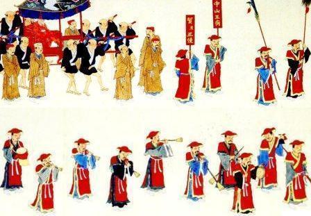
A Ryukyuan embassy in Edo.
| Historical population | ||
|---|---|---|
| Year | Pop. | ±% p.a. |
| 1970 | 945,111 | — |
| 1975 | 1,042,572 | +1.98% |
| 1980 | 1,106,559 | +1.20% |
| 1985 | 1,179,097 | +1.28% |
| 1990 | 1,222,398 | +0.72% |
| 1995 | 1,273,440 | +0.82% |
| 2000 | 1,318,220 | +0.69% |
| 2005 | 1,361,594 | +0.65% |
| 2010 | 1,392,818 | +0.45% |
| 2015 | 1,434,138 | +0.59% |
| source:[10] | ||
The oldest evidence of human existence on the Ryukyu islands is from the Stone Age and was discovered in Naha[11] and Yaeyama.[12] Some human bone fragments from the Paleolithic era were unearthed from a site in Naha, but the artifact was lost in transportation before it was examined to be Paleolithic or not.[11] Japanese Jōmon influences are dominant on the Okinawa Islands, although clay vessels on the Sakishima Islands have a commonality with those in Taiwan.[1]
The first mention of the word Ryukyu was written in the Book of Sui.[2] Okinawa was the Japanese word identifying the islands, first seen in the biography of Jianzhen, written in 779.[3] Agricultural societies begun in the 8th century slowly developed until the 12th century.[4][19][20] Since the islands are located at the eastern perimeter of the East China Sea relatively close to Japan, China and South-East Asia, the Ryukyu Kingdom became a prosperous trading nation. Also during this period, many Gusukus, similar to castles, were constructed. The Ryukyu Kingdom entered into the Imperial Chinese tributary system under the Ming dynasty beginning in the 15th century, which established economic relations between the two nations.
In 1609, the Shimazu clan, which controlled the region that is now Kagoshima Prefecture, invaded the Ryukyu Kingdom. The Ryukyu Kingdom was obliged to agree to form a suzerain-vassal relationship with the Satsuma and the Tokugawa shogunate, while maintaining its previous role within the Chinese tributary system; Ryukyuan sovereignty was maintained since complete annexation would have created a conflict with China. The Satsuma clan earned considerable profits from trade with China during a period in which foreign trade was heavily restricted by the shogunate.
Although Satsuma maintained strong influence over the islands, the Ryukyu Kingdom maintained a considerable degree of domestic political freedom for over two hundred years.
Four years after the 1868 Meiji Restoration, the Japanese government, through military incursions, officially annexed the kingdom and renamed it Ryukyu han. At the time, the Qing Empire asserted a nominal suzerainty over the islands of the Ryukyu Kingdom, since the Ryūkyū Kingdom was also a member state of the Chinese tributary system. Ryukyu han became Okinawa Prefecture of Japan in 1879, even though all other hans had become prefectures of Japan in 1872. In 1912, Okinawans first obtained the right to vote for representatives to the National Diet (国会) which had been established in 1890.[21]
1945–1965
Near the end of World War II, in 1945, the US Army and Marine Corps invaded Okinawa with 185,000 troops. A third of the civilian population died;[22] a quarter of the civilian population died during the 1945 Battle of Okinawa alone.[23] The dead, of all nationalities, are commemorated at the Cornerstone of Peace. After the end of World War II, the Ryukyu independence movement developed, while Okinawa was under United States Military Government of the Ryukyu Islands administration for 27 years. During this "trusteeship rule", the United States established numerous military bases on the Ryukyu islands.
During the Korean War, B-29 Superfortresses flew bombing missions over Korea from Kadena Air Base on Okinawa. The military buildup on the island during the Cold War increased a division between local inhabitants and the American military. Under the 1952 Treaty of Mutual Cooperation and Security between the United States and Japan, the United States Forces Japan (USFJ) have maintained a large military presence.
During the mid-1950s, the U.S. seized land from Okinawans to build new bases or expand currently-existing ones.
According to the Melvin Price Report, by 1955, the military had displaced 250,000 residents.[24]
Since 1960, the U.S. and Japan have maintained an agreement that allows the U.S. to secretly bring nuclear weapons into Japanese ports.[25][26][27] The Japanese tended to oppose the introduction of nuclear arms into Japanese territory[28] by the government's assertion of Japan's non-nuclear policy and a statement of the Three Non-Nuclear Principles. Most of the weapons were alleged to be stored in ammunition bunkers at Kadena Air Base.[29] Between 1954 and 1972, 19 different types of nuclear weapons were deployed in Okinawa, but with fewer than around 1,000 warheads at any one time.[30]
1965–1972 (Vietnam War)
Between 1965 and 1972, Okinawa was a key staging point for the United States in its military operations directed towards North Vietnam. Along with Guam, it presented a geographically strategic launch pad for covert bombing missions over Cambodia and Laos.[31] Anti-Vietnam War sentiment became linked politically to the movement for reversion of Okinawa to Japan. In 1965, the US military bases, earlier viewed as paternal post war protection, were increasingly seen as aggressive. The Vietnam War highlighted the differences between the United States and Okinawa, but showed a commonality between the islands and mainland Japan.[32]
As controversy grew regarding the alleged placement of nuclear weapons on Okinawa, fears intensified over the escalation of the Vietnam War. Okinawa was then perceived, by some inside Japan, as a potential target for China, should the communist government feel threatened by the United States.[33] American military secrecy blocked any local reporting on what was actually occurring at bases such as Kadena Air Base. As information leaked out, and images of air strikes were published, the local population began to fear the potential for retaliation.[32]
Political leaders such as Oda Makoto, a major figure in the Beheiren movement (Foundation of Citizens for Peace in Vietnam), believed, that the return of Okinawa to Japan would lead to the removal of U.S. forces ending Japan's involvement in Vietnam.[34] In a speech delivered in 1967 Oda was critical of Prime Minister Sato’s unilateral support of America’s War in Vietnam claiming "Realistically we are all guilty of complicity in the Vietnam War".[34] The Beheiren became a more visible anti-war movement on Okinawa as the American involvement in Vietnam intensified. The movement employed tactics ranging from demonstrations, to handing leaflets to soldiers, sailors, airmen and Marines directly, warning of the implications for a third World War.[34]
The US military bases on Okinawa became a focal point for anti-Vietnam War sentiment. By 1969, over 50,000 American military personnel were stationed on Okinawa.[36] The United States Department of Defense began referring to Okinawa as "The Keystone of the Pacific". This slogan was imprinted on local U.S. military license plates.[34]
In 1969, chemical weapons leaked from the US storage depot at Chibana in central Okinawa, under Operation Red Hat. Evacuations of residents took place over a wide area for two months. Even two years later, government investigators found that Okinawans and the environment near the leak were still suffering because of the depot.[38]
In 1972, the U.S. government handed over the islands to Japanese administration.[39]
1973–2006

U.S. military facilities in Okinawa
In a 1981 interview with the Mainichi Shimbun, Edwin O. Reischauer, former U.S. ambassador to Japan, said that U.S. naval ships armed with nuclear weapons stopped at Japanese ports on a routine duty, and this was approved by the Japanese government.
The 1995 rape of a 12-year-old girl by U.S. servicemen triggered large protests in Okinawa. Reports by the local media of accidents and crimes committed by U.S. servicemen have reduced the local population's support for the U.S. military bases. A strong emotional response has emerged from certain incidents. As a result, the media has drawn renewed interest in the Ryukyu independence movement.
Documents declassified in 1997 proved that both tactical and strategic weapons have been maintained in Okinawa.[38][40] In 1999 and 2002, the Japan Times and the Okinawa Times reported speculation that not all weapons were removed from Okinawa.[41][42] On October 25, 2005, after a decade of negotiations, the governments of the US and Japan officially agreed to move Marine Corps Air Station Futenma from its location in the densely populated city of Ginowan to the more northerly and remote Camp Schwab in Nago by building a heliport with a shorter runway, partly on Camp Schwab land and partly running into the sea.[22] The move is partly an attempt to relieve tensions between the people of Okinawa and the Marine Corps.
2007–present
According to a 2007 Okinawa Times poll, 85 percent of Okinawans opposed the presence of the U.S. military,[44] because of noise pollution from military drills, the risk of aircraft accidents,[5] environmental degradation,[45] and crowding from the number of personnel there,[46] although 73.4 percent of Japanese citizens appreciated the mutual security treaty with the U.S. and the presence of the USFJ.[47] In another poll conducted by the Asahi Shimbun in May 2010, 43 percent of the Okinawan population wanted the complete closure of the U.S. bases, 42 percent wanted reduction and 11 percent wanted the maintenance of the status quo.[48] Okinawan feelings about the U.S. military are complex, and some of the resentment towards the U.S. bases is directed towards the government in Tokyo, perceived as being insensitive to Okinawan needs and using Okinawa to house bases not desired elsewhere in Japan.
In early 2008, U.S.
Secretary of State Condoleezza Rice apologized after a series of crimes involving American troops in Japan, including the rape of a young girl of 14 by a Marine on Okinawa. The U.S. military also imposed a temporary 24-hour curfew on military personnel and their families to ease the anger of local residents.[49] Some cited statistics that the crime rate of military personnel is consistently less than that of the general Okinawan population.[50] However, some criticized the statistics as unreliable, since violence against women is under-reported.[51]
In 2009, a new Japanese government came to power and froze the US forces relocation plan, but in April 2010 indicated their interest in resolving the issue by proposing a modified plan.[53]
A study done in 2010 found that the prolonged exposure to aircraft noise around the Kadena Air Base and other military bases cause health issues such as a disrupted sleep pattern, high blood pressure, weakening of the immune system in children, and a loss of hearing.[54]
In 2011, it was reported that the U.S. military—contrary to repeated denials by the Pentagon—had kept tens of thousands of barrels of Agent Orange on the island. The Japanese and American governments have angered some U.S. veterans, who believe they were poisoned by Agent Orange while serving on the island, by characterizing their statements regarding Agent Orange as "dubious", and ignoring their requests for compensation. Reports that more than a third of the barrels developed leaks have led Okinawans to ask for environmental investigations, but as of 2012 both Tokyo and Washington refused such action.[55] Jon Mitchell has reported concern that the U.S. used American Marines as chemical-agent guinea pigs.[56]
On September 30, 2018, Denny Tamaki was elected as the next governor of Okinawa prefecture, after a campaign focused on sharply reducing the U.S. military presence on the island.[57]
Marine Corps Air Station Futenma relocation, 2006–present
As of December 2014, one ongoing issue is the relocation of Marine Corps Air Station Futenma. First promised to be moved off the island and then later within the island, as of November 2014 the future of any relocation is uncertain with the election of base-opponent Onaga as Okinawa governor.[58] Onaga won against the incumbent Nakaima who had earlier approved landfill work to move the base to Camp Schwab in Henoko. However, Onaga has promised to veto the landfill work needed for the new base to be built and insisted Futenma should be moved outside of Okinawa.[59]
In 2009, Japan's former foreign minister Katsuya Okada stated that he wanted to review the deployment of U.S. troops in Japan to ease the burden on the people of Okinawa (Associated Press, October 7, 2009) 5,000 of 9,000 Marines will be deployed at Guam and the rest will be deployed at Hawaii and Australia. Japan will pay $3.1 billion cash for the moving and for developing joint training ranges on Guam and on Tinian and Pagan in the U.S.-controlled Northern Mariana Islands.[62][63][64]
As of 2014, the US still maintains Air Force, Marine, Navy, and Army military installations on the islands.
These bases include Kadena Air Base, Camp Foster, Marine Corps Air Station Futenma, Camp Hansen, Camp Schwab, Torii Station, Camp Kinser, and Camp Gonsalves. The area of 14 U.S. bases are 233 square kilometres (90 sq mi), occupying 18 percent of the main island. Okinawa hosts about two-thirds of the 50,000 American forces in Japan although the islands account for less than one percent of total lands in Japan.[43]
Suburbs have grown towards and now surround two historic major bases, Futenma and Kadena.
One third (9,852 acres (39.87 km2)) of the land used by the U.S. military is the Marine Corps Northern Training Area (known also as Camp Gonsalves or JWTC) in the north of the island.[65]
On December 21, 2016, 10,000 acres of Okinawa Northern Training Area was returned to Japan.[66]
On June 25, 2018, Okinawa residents held a protest demonstration at sea against scheduled land reclamation work for the relocation of a U.S. military base within Japan's southernmost island prefecture.
A protest gathered hundreds of people.[67]
Helipads construction in Takae (Yanbaru forest)
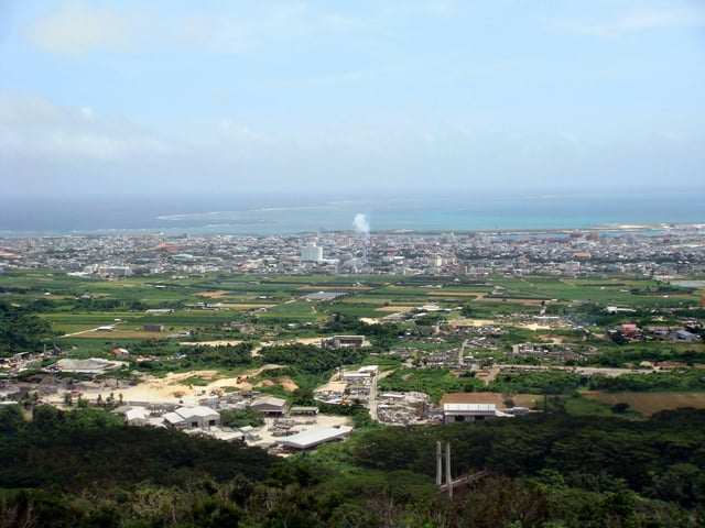
Geography
Major islands
The islands of Okinawa Prefecture
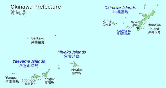
The islands comprising the prefecture are the southern two thirds of the archipelago of the Ryūkyū Islands (琉球諸島, Ryūkyū-shotō). Okinawa's inhabited islands are typically divided into three geographical archipelagos. From northeast to southwest:
Okinawa Islands (沖縄諸島, Okinawa Shotō) Ie-jima Kume-jima Okinawa Island Kerama Islands
Miyako Islands Miyako-jima
Yaeyama Islands Iriomote-jima Ishigaki Island Yonaguni
Senkaku Islands
Daitō Islands Minamidaitōjima Kitadaitōjima Okidaitōjima
Cities

Map of Okinawa Prefecture City Town
Naha
Ishigaki
Eleven cities are located within the Okinawa Prefecture.
Okinawan names are in parentheses:
Naha (Naafa) (capital)
Ginowan (Jinoon)
Ishigaki (Ishigachi)
Itoman (Ichuman)
Miyakojima (Naaku, Myaaku)
Nago (Nagu)
Nanjō (Nanjoo)
Okinawa (Uchinaa) (formerly Koza)
Tomigusuku (Tumigushiku)
Urasoe (Urashii)
Uruma
Towns and villages
These are the towns and villages in each district:
Kunigami District (Kunjan) Ginoza (Jinuja) Higashi (Agarijima) Ie (Iijima) Kin (Chin) Kunigami (Kunjan) Motobu (Mutubu) Nakijin (Nachijin) Onna (Unna) Ōgimi (Ujimi)
Miyako District (Naaku, Myaaku) Tarama
Nakagami District (Nakajan) Chatan Kadena (Kadina) Kitanakagusuku Nakagusuku (Nakagushiku) Nishihara (Nishibaru) Yomitan (Yuntan)
Shimajiri District Aguni Haebaru (Feebaru) Iheya (Ihyaa) Izena (Ijina) Kitadaitō (Ufuagarijima) Kumejima (Kumijima) Minamidaitō Tokashiki (Tukashichi) Tonaki (Tunachi) Yaese Yonabaru (Yunabaru) Zamami (Jamami)
Yaeyama District (Eema, Yaima) Taketomi (Dakidun, Teedun) Yonaguni (Yunaguni, Dunan)
Town mergers
Natural parks
As of 31 March 2019, 36 percent of the total land area of the prefecture was designated as Natural Parks, namely the Iriomote-Ishigaki, Kerama Shotō, and Yanbaru National Parks; Okinawa Kaigan and Okinawa Senseki Quasi-National Parks; and Irabu, Kumejima, Tarama, and Tonaki Prefectural Natural Parks.[71]
Fauna
The dugong is an endangered marine mammal related to the manatee.[72] Iriomote is home to one of the world's rarest and most endangered cat species, the Iriomote cat. The region is also home to at least one endemic pit viper, Trimeresurus elegans. Coral reefs found in this region of Japan provide an environment for a diverse marine fauna. The sea turtles return yearly to the southern islands of Okinawa to lay their eggs. The summer months carry warnings to swimmers regarding venomous jellyfish and other dangerous sea creatures.
Flora
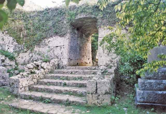
Arch at an Okinawan Castle ruin.
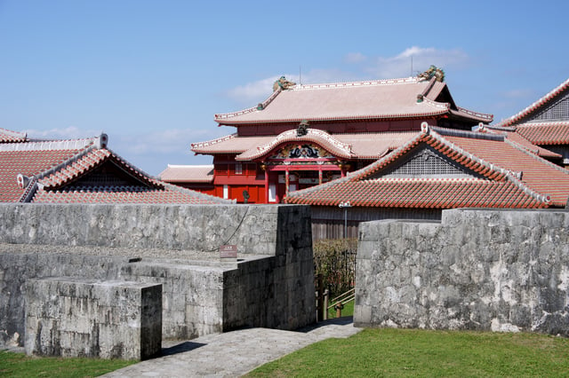
Shuri Castle, Naha
Okinawa is a major producer of sugar cane, pineapple, papaya, and other tropical fruit, and the Southeast Botanical Gardens represent tropical plant species.
Geology
The island is largely composed of coral, and rainwater filtering through that coral has given the island many caves, which played an important role in the Battle of Okinawa. Gyokusendo[73] is an extensive limestone cave in the southern part of Okinawa's main island.
Climate
The island experiences temperatures above 20 °C (68 °F) for most of the year.
The climate of the islands ranges from humid subtropical climate (Köppen climate classification Cfa) in the north, such as Okinawa Island, to tropical rainforest climate (Köppen climate classification Af) in the south such as Iriomote Island. The islands of Okinawa are surrounded by some of the most abundant coral reefs found in the world.[74][75] The world's largest colony of rare blue coral is found off of Ishigaki Island.[76] Snowfall is unheard of at sea level. However, on January 24, 2016, sleet was reported in Nago on Okinawa Island for the first time on record.[77]
Demography
Language and culture
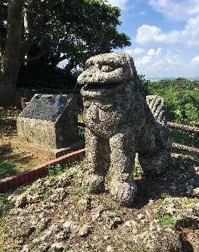
Shisa
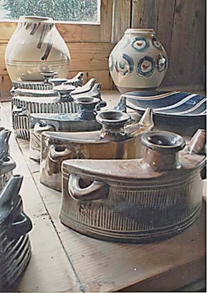
Awamori pots
Having been a separate nation until 1879, Okinawan language and culture differ in many ways from those of mainland Japan.
Language
There remain six Ryukyuan languages which are incomprehensible to Japanese speakers, although they are considered to make up the family of Japonic languages along with Japanese. These languages are in decline as Standard Japanese is being used by the younger generation. They are generally perceived as "dialects" by mainland Japanese and some Okinawans themselves. Standard Japanese is almost always used in formal situations. In informal situations, de facto everyday language among Okinawans under age 60 is Okinawa-accented mainland Japanese ("Okinawan Japanese"), which is often misunderstood as the Okinawan language proper. The actual traditional Okinawan language is still used in traditional cultural activities, such as folk music and folk dance. There is a radio news program in the language as well.[79]
Religion
Okinawans have traditionally followed Ryukyuan religious beliefs, generally characterized by ancestor worship and the respecting of relationships between the living, the dead, and the gods and spirits of the natural world.[80]
Cultural influences
Okinawan culture bears traces of its various trading partners.
One can find Chinese, Thai and Austronesian influences in the island's customs. Perhaps Okinawa's most famous cultural export is karate, probably a product of the close ties with and influence of China on Okinawan culture. Karate is thought to be a synthesis of Chinese kung fu with traditional Okinawan martial arts. Okinawans' reputation as wily resisters of being influenced by conquerors is depicted in the 1956 Hollywood film, The Teahouse of the August Moon
Another traditional Okinawan product that owes its existence to Okinawa's trading history is awamori—an Okinawan distilled spirit made from indica rice imported from Thailand.
Other cultural characteristics
Other prominent examples of Okinawan culture include the sanshin—a three-stringed Okinawan instrument, closely related to the Chinese sanxian, and ancestor of the Japanese shamisen, somewhat similar to a banjo. Its body is often bound with snakeskin (from pythons, imported from elsewhere in Asia, rather than from Okinawa's venomous Trimeresurus flavoviridis, which are too small for this purpose). Okinawan culture also features the eisa dance, a traditional drumming dance. A traditional craft, the fabric named bingata, is made in workshops on the main island and elsewhere.
The Okinawan diet consist of low-fat, low-salt foods, such as whole fruits and vegetables, legumes, tofu, and seaweed. Okinawans are known for their longevity. This particular island is a so-called Blue Zone, an area where the people live longer than most others elsewhere in the world. Five times as many Okinawans live to be 100 as in the rest of Japan, and Japanese are already the longest-lived ethnic group globally.[81]%20magazine%2C%20June%201993]]%20magazine%2C%20June%201993]]*s of 2002 there were 34.7 centenarians for every 100,000 inhabitants, which is the highest ratio worldwide.
A cultural feature of the Okinawans is the forming of moais. A moai is a community social gathering and groups that come together to provide financial and emotional support through emotional bonding, advice giving, and social funding. This provides a sense of security for the community members and as mentioned in the Blue Zone studies, may be a contributing factor to the longevity of its people.[83]
In recent years, Okinawan literature has been appreciated outside of the Ryukyu archipelago. Two Okinawan writers have received the Akutagawa Prize: Matayoshi Eiki in 1995 for The Pig's Retribution (豚の報い, Buta no mukui) and Medoruma Shun in 1997 for A Drop of Water (Suiteki). The prize was also won by Okinawans in 1967 by Tatsuhiro Oshiro for Cocktail Party (Kakuteru Pāti) and in 1971 by Mineo Higashi for Okinawan Boy (Okinawa no Shōnen).[84][85]
Karate
Karate originated in Okinawa. Over time, it developed into several styles and sub-styles. On Okinawa, the three main styles are considered to be Shōrin-ryū, Gōjū-ryū and Uechi-ryū. Internationally, the various styles and sub-styles include Matsubayashi-ryū, Wadō-ryū, Isshin-ryū, Shōrinkan, Shotokan, Shitō-ryū, Shōrinjiryū Kenkōkan, Shorinjiryu Koshinkai, and Shōrinji-ryū.
Architecture
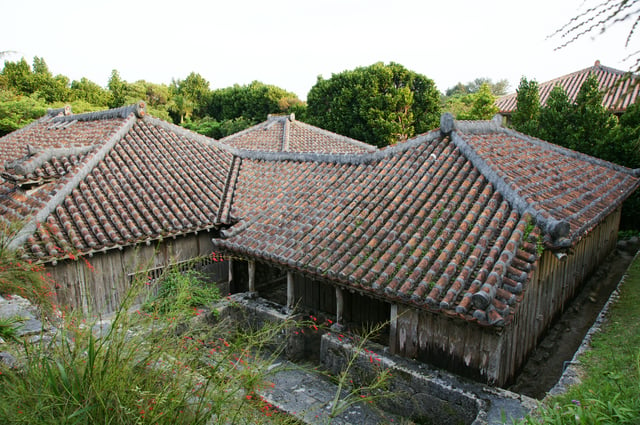
Nakamura house
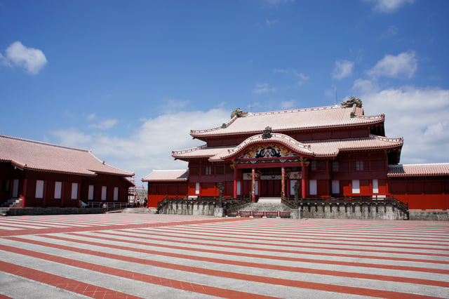
Shuri Castle in Naha
Despite widespread destruction during World War II, there are many remains of a unique type of castle or fortress known as gusuku; the most significant are now inscribed on the UNESCO World Heritage List (Gusuku Sites and Related Properties of the Kingdom of Ryukyu).[86] In addition, twenty-three Ryukyuan architectural complexes and forty historic sites have been designated for protection by the national government.[87] Shuri Castle in Naha is an UNESCO World Heritage Site.
Whereas most homes in Japan are made from wood and allow free-flow of air to combat humidity, typical modern homes in Okinawa are made from concrete with barred windows to protect from flying plant debris and to withstand regular typhoons. Roofs are designed with strong winds in mind, in which each tile is cemented on and not merely layered as seen with many homes in Japan. The Nakamura House (ja:中村家住宅 (沖縄県)) is an original 18th century farmhouse in Kitanakagusuki.
Many roofs also display a lion-dog statue, called a shisa
Education
The public schools in Okinawa are overseen by the Okinawa Prefectural Board of Education. The agency directly operates several public high schools[88] including Okinawa Shogaku High School. The U.S. Department of Defense Dependents Schools (DoDDS) operates 13 schools total in Okinawa. Seven of these schools are located on Kadena Air Base.
Okinawa has many types of private schools.
Some of them are cram schools, also known as juku. Others, such as Nova, solely teach language. People also attend small language schools[89].
There are 10 colleges/universities in Okinawa, including the University of the Ryukyus, the only national university in the prefecture, and the Okinawa Institute of Science and Technology, a new international research institute. Okinawa's American military bases also host the Asian Division of the University of Maryland University College.
Sports
- Association football
FC Ryukyu (Naha)
- Basketball
Ryukyu Golden Kings (Naha)
- Handball
Ryukyu Corazon[90] (Naha)
- Baseball
Announced on July 18, 2019, BASE Okinawa Baseball Club will be forming the first-ever professional baseball team on Okinawa, the Ryukyu Blue Oceans.
The team is expected to be fully organized by January 2020 and intends on joining the Nippon Professional Baseball league.[91]
In addition, various baseball teams from Japan hold training during the winter in Okinawa prefecture as it is the warmest prefecture of Japan with no snow and higher temperatures than other prefectures.
Softbank Hawks
Yokohama BayStars
Chunichi Dragons
Yakult Swallows
- Golf
There are numerous golf courses in the prefecture, and there was formerly a professional tournament called the Okinawa Open.
Transportation
Air transportation
Aguni Airport
Hateruma Airport
Iejima Airport
New Ishigaki Airport
Kerama Airport
Kita Daito Airport
Kumejima Airport
Minami-Daito Airport
Miyako Airport
Naha Airport
Shimojijima Airport
Tarama Airport
Yonaguni Airport
Highways
Okinawa Expressway
Naha Airport Expressway
Route 58
Route 329
Route 330
Route 331
Route 332
Route 390
Route 449
Route 505
Route 506
Route 507
Rail
Okinawa Urban Monorail
Ports
The major ports of Okinawa include:
Economy
The 34 US military installations on Okinawa are financially supported by the U.S. and Japan.[98] The bases provide jobs for Okinawans, both directly and indirectly; In 2011, the U.S. military employed over 9,800 Japanese workers in Okinawa.[98] As of 2012 the bases accounted for 4 or 5 percent of the economy.[99] However, Koji Taira argued in 1997 that because the U.S. bases occupy around 20 percent of Okinawa's land, they impose a deadweight loss of 15 percent on the Okinawan economy.[100] The Tokyo government also pays the prefectural government around ¥10 billion per year[98] in compensation for the American presence, including, for instance, rent paid by the Japanese government to the Okinawans on whose land American bases are situated.[101] A 2005 report by the U.S. Forces Japan Okinawa Area Field Office estimated that in 2003 the combined U.S. and Japanese base-related spending contributed $1.9 billion to the local economy.[102] On January 13, 2015, In response to the citizens electing governor Takeshi Onaga, the national government announced that Okinawa's funding will be cut, due to the governor's stance on removing the US military bases from Okinawa, which the national government doesn't want happening.[103][104]
The Okinawa Convention and Visitors Bureau is exploring the possibility of using facilities on the military bases for large-scale Meetings, incentives, conferencing, exhibitions events.[105]
Military
United States military installations
United States Marine Corps Marine Corps Base Camp Smedley D. Butler Camp Foster Marine Corps Air Station Futenma Camp Kinser Camp Courtney Camp McTureous Camp Hansen Camp Schwab Camp Gonsalves (Jungle Warfare Training Center)
United States Air Force Kadena Air Base Okuma Beach Resort [107]
United States Navy Camp Lester (Camp Kuwae)[106] Camp Shields Naval Facility White Beach
United States Army Torii Station Fort Buckner Naha Military Port
Notable people
Chōjun Miyagi founder of Gōjū-ryū, "hard/soft" style of Okinawan Karate.
Uechi Kanbun was the founder of Uechi-ryū, one of the primary karate styles of Okinawa.
Mitsuru Ushijima was the Japanese general at the Battle of Okinawa during the final stages of World War II.
Isamu Chō was an officer in the Imperial Japanese Army known for his support of ultranationalist politics and involvement in a number of attempted military and right-wing coup d'états in pre-World War II Japan.
Ōta Minoru was an admiral in the Imperial Japanese Navy during World War II, and the final commander of the Japanese naval forces defending the Oroku Peninsula during the Battle of Okinawa.
Sato Eisaku was a Japanese politician and the 61st, 62nd and 63rd Prime Minister of Japan. While he was premier in 1972, Okinawa was returned to Japan.
Yabu Kentsū was a prominent teacher of Shōrin-ryū karate in Okinawa from the 1910s until the 1930s, and was among the first people to demonstrate karate in Hawaii.
Takuji Iwasaki was a meteorologist, biologist, ethnologist historian.
Matayoshi Eiki Okinawan novel writer, winner of Akutagawa prize
Gackt Japanese pop rock singer-songwriter, actor, author
Namie Amuro Japanese R&B, hip hop and pop singer
Beni Japanese pop and R&B singer
Ben Shepherd Bassist of the band Soundgarden
Noriyuki Sugasawa basketball player
Orange Range Japanese rock band
Stereopony Japanese all-female pop rock band
Tamlyn Tomita actress and singer
Rino Nakasone Razalan professional dancer and choreographer.
Yukie Nakama singer, musician and actress
Daichi Miura Japanese pop singer, dancer and choreographer.
Yui Aragaki actress, singer, and model
Hearts Grow Japanese band
Aisa Senda, Japanese singer, actress and TV presenter in Taiwan
Robert Griffin III, American football quarterback, Heisman Trophy winner
Dave Roberts, Major League Baseball player and manager
Rimi Natsukawa (夏川 りみ Natsukawa Rimi), Japanese female pop singers
See also
Okinawa Prefectural Assembly
Okinawan Americans
People from Okinawa Prefecture
Ryukyuan people