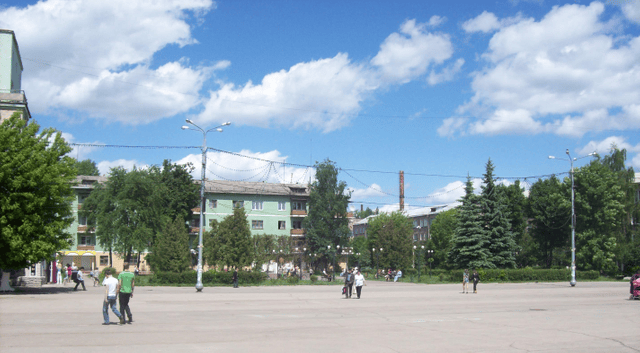
Novomoskovsk, Russia

Novomoskovsk, Russia

Novomoskovsk Новомосковск | |
|---|---|
City[1] | |
Location of Novomoskovsk | |
| Coordinates:54°05′N 38°13′E [15] | |
| Country | Russia |
| Federal subject | Tula Oblast[1] |
| Administrative district | Novomoskovsky District[1] |
| City under district jurisdiction | Novomoskovsk[2] |
| Founded | 1930 |
| City status since | 1930 |
| Government | |
| • Body | Assembly of Deputies[3] |
| • Head | Anatoly Prorokov |
| Area | |
| • Total | 74.7 km2(28.8 sq mi) |
| Elevation | 220 m (720 ft) |
| Population (2010 Census)[5] | |
| • Total | 131,386 |
| • Estimate (2018)[6] | 124,787 (-5%) |
| • Rank | 124th in 2010 |
| • Density | 1,800/km2(4,600/sq mi) |
Administrative status | |
| • Capital of | Novomoskovsky District[1], Novomoskovsk Town Under District Jurisdiction[7] |
Municipal status | |
| • Urban okrug | Novomoskovsk Urban Okrug[8] |
| • Capital of | Novomoskovsk Urban Okrug[9] |
| Time zone | UTC+3 (MSK [10]) |
| Postal code(s)[11] | 301650–301654, 301657, 301659–301666, 301668, 301670, 301679 |
| Dialing code(s) | +7 48762 |
| OKTMO ID | 70724000001 |
| City Day | May 25 |
| Twin towns | Kremenchuk |
| Website | www.nmosk.ru [16] |
Novomoskovsk (Russian: Новомоско́вск) is a city and the administrative center of Novomoskovsky District in Tula Oblast, Russia, located at the source of the Don and Shat Rivers. Population: 131,386 (2010 Census);[5] 134,081 (2002 Census);[12] 146,302 (1989 Census);[13] 143,000 (1974); 107,000 (1959); 76,000 (1939).
Novomoskovsk Новомосковск | |
|---|---|
City[1] | |
Location of Novomoskovsk | |
| Coordinates:54°05′N 38°13′E [15] | |
| Country | Russia |
| Federal subject | Tula Oblast[1] |
| Administrative district | Novomoskovsky District[1] |
| City under district jurisdiction | Novomoskovsk[2] |
| Founded | 1930 |
| City status since | 1930 |
| Government | |
| • Body | Assembly of Deputies[3] |
| • Head | Anatoly Prorokov |
| Area | |
| • Total | 74.7 km2(28.8 sq mi) |
| Elevation | 220 m (720 ft) |
| Population (2010 Census)[5] | |
| • Total | 131,386 |
| • Estimate (2018)[6] | 124,787 (-5%) |
| • Rank | 124th in 2010 |
| • Density | 1,800/km2(4,600/sq mi) |
Administrative status | |
| • Capital of | Novomoskovsky District[1], Novomoskovsk Town Under District Jurisdiction[7] |
Municipal status | |
| • Urban okrug | Novomoskovsk Urban Okrug[8] |
| • Capital of | Novomoskovsk Urban Okrug[9] |
| Time zone | UTC+3 (MSK [10]) |
| Postal code(s)[11] | 301650–301654, 301657, 301659–301666, 301668, 301670, 301679 |
| Dialing code(s) | +7 48762 |
| OKTMO ID | 70724000001 |
| City Day | May 25 |
| Twin towns | Kremenchuk |
| Website | www.nmosk.ru [16] |
History

The source of the Don River in Novomoskovsk
The city originated in the 18th century as the family manor of Counts Bobrinsky, who industrialized it towards the end of the 19th century. The city, under the name of Bobriki (Бобрики) was officially established in 1930 and continued to develop as a coal (lignite) mining center throughout the Soviet period. In 1933, it was renamed Stalinogorsk (Сталиногорск). During World War II, the city was occupied by the German Army from November 22, 1941 to December 11, 1941. In 1961, it was given its present name. The city was awarded the Order of the Red Banner of Labor on January 14, 1971.
Administrative and municipal status
Within the framework of administrative divisions, Novomoskovsk serves as the administrative center of Novomoskovsky District.[1] As an administrative division, it is, together with three rural localities, incorporated within Novomoskovsky District as Novomoskovsk City Under District Jurisdiction.[2] As a municipal division, the territories of Novomoskovsk Town Under District Jurisdiction and of thirteen rural okrugs of Novomoskovsky District are incorporated as Novomoskovsk Urban Okrug.[8][14]
Notable people
Ksenia Semyonova, gymnast
Irina Sebrova, aviator
Twin towns and sister cities
Novomoskovsk is twinned with:
[[INLINE_IMAGE|//upload.wikimedia.org/wikipedia/commons/thumb/4/49/Flag_of_Ukraine.svg/23px-Flag_of_Ukraine.svg.png|//upload.wikimedia.org/wikipedia/commons/thumb/4/49/Flag_of_Ukraine.svg/35px-Flag_of_Ukraine.svg.png 1.5x, //upload.wikimedia.org/wikipedia/commons/thumb/4/49/Flag_of_Ukraine.svg/45px-Flag_of_Ukraine.svg.png 2x|Ukraine|h15|w23|thumbborder flagicon-img flagicon-img]] Kremenchuk, Ukraine
[[INLINE_IMAGE|//upload.wikimedia.org/wikipedia/commons/thumb/b/b4/Flag_of_Turkey.svg/23px-Flag_of_Turkey.svg.png|//upload.wikimedia.org/wikipedia/commons/thumb/b/b4/Flag_of_Turkey.svg/35px-Flag_of_Turkey.svg.png 1.5x, //upload.wikimedia.org/wikipedia/commons/thumb/b/b4/Flag_of_Turkey.svg/45px-Flag_of_Turkey.svg.png 2x|Turkey|h15|w23|thumbborder flagicon-img flagicon-img]] Kuşadası, Turkey
[[INLINE_IMAGE|//upload.wikimedia.org/wikipedia/commons/thumb/e/e6/Flag_of_Slovakia.svg/23px-Flag_of_Slovakia.svg.png|//upload.wikimedia.org/wikipedia/commons/thumb/e/e6/Flag_of_Slovakia.svg/35px-Flag_of_Slovakia.svg.png 1.5x, //upload.wikimedia.org/wikipedia/commons/thumb/e/e6/Flag_of_Slovakia.svg/45px-Flag_of_Slovakia.svg.png 2x|Slovakia|h15|w23|thumbborder flagicon-img flagicon-img]] Prievidza, Slovakia


