Margreid an der Weinstraße
1.84K VIEWS
Everipedia is now IQ.wiki - Join the IQ Brainlist and our Discord for early access to editing on the new platform and to participate in the beta testing.

Margreid an der Weinstraße
Margreid an der Weinstraße

Margreid | |
|---|---|
| Gemeinde Margreid an der Weinstraße Comune di Magrè sulla Strada del Vino | |
Location of Margreid | |
| Coordinates:46°17′N 11°13′E [7] | |
| Country | Italy |
| Region | Trentino-Alto Adige/Südtirol |
| Province | South Tyrol (BZ) |
| Frazioni | ****Unterfennberg (Favogna di Sotto) |
| Government | |
| • Mayor | Theresia Degasperi |
| Area | |
| • Total | 13.86 km2(5.35 sq mi) |
| Elevation | 241 m (791 ft) |
| Population (2018-01-01)[2] | |
| • Total | 1,295 |
| • Density | 93/km2(240/sq mi) |
| Demonym(s) | German: Margreider Italian: Magresi |
| Time zone | UTC+1 (CET) |
| • Summer (DST) | UTC+2 (CEST) |
| Postal code | 39040 |
| Dialing code | 0471 |
| Website | Official website [8] |
Margreid an der Weinstraße (German pronunciation: [marˈgraɪ̯t an dɐ ˈvaɪ̯nˌʃtraˑsə]; Italian: Magrè sulla Strada del Vino [maˈɡrɛ ˈsulla ˈstraːda del ˈviːno]), often abbreviated to Margreid or Magrè, is a comune (municipality) in South Tyrol in northern Italy, located about 25 kilometres (16 mi) southwest of the city of Bolzano.
Margreid | |
|---|---|
| Gemeinde Margreid an der Weinstraße Comune di Magrè sulla Strada del Vino | |
Location of Margreid | |
| Coordinates:46°17′N 11°13′E [7] | |
| Country | Italy |
| Region | Trentino-Alto Adige/Südtirol |
| Province | South Tyrol (BZ) |
| Frazioni | ****Unterfennberg (Favogna di Sotto) |
| Government | |
| • Mayor | Theresia Degasperi |
| Area | |
| • Total | 13.86 km2(5.35 sq mi) |
| Elevation | 241 m (791 ft) |
| Population (2018-01-01)[2] | |
| • Total | 1,295 |
| • Density | 93/km2(240/sq mi) |
| Demonym(s) | German: Margreider Italian: Magresi |
| Time zone | UTC+1 (CET) |
| • Summer (DST) | UTC+2 (CEST) |
| Postal code | 39040 |
| Dialing code | 0471 |
| Website | Official website [8] |
Coat-of-arms
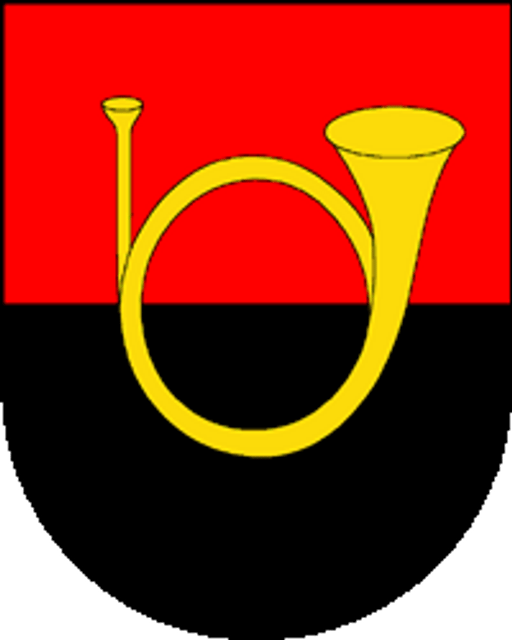
The emblem is party per fess, of gules and sable, with an or horn. It is the arms of the family Ob der Platten who lived in the village until 1511. The emblem, which was adopted in 1968, appeared as a seal in 1780.[4]
Linguistic distribution
According to the 2011 census, 84.33% of the population speak German, 15.22% Italian and 0.45% Ladin as first language.[5]
References
[1]
Citation Linkwww.istat.it"Superficie di Comuni Province e Regioni italiane al 9 ottobre 2011". Istat. Retrieved 16 March 2019.
Sep 29, 2019, 3:46 PM
[2]
Citation Linkdemo.istat.it"Popolazione Residente al 1° Gennaio 2018". Istat. Retrieved 16 March 2019.
Sep 29, 2019, 3:46 PM
[3]
Citation Linkopenlibrary.orgAll demographics and other statistics: Italian statistical institute Istat.
Sep 29, 2019, 3:46 PM
[5]
Citation Linkwww.provinz.bz.it"Volkszählung 2011/Censimento della popolazione 2011". astat info. Provincial Statistics Institute of the Autonomous Province of South Tyrol (38): 6–7. June 2012. Retrieved 2012-06-14.
Sep 29, 2019, 3:46 PM
[9]
Citation Linkwww.istat.it"Superficie di Comuni Province e Regioni italiane al 9 ottobre 2011"
Sep 29, 2019, 3:46 PM
[12]
Citation Linkwww.provinz.bz.it"Volkszählung 2011/Censimento della popolazione 2011"
Sep 29, 2019, 3:46 PM
[14]
Citation Linken.wikipedia.orgThe original version of this page is from Wikipedia, you can edit the page right here on Everipedia.Text is available under the Creative Commons Attribution-ShareAlike License.Additional terms may apply.See everipedia.org/everipedia-termsfor further details.Images/media credited individually (click the icon for details).
Sep 29, 2019, 3:46 PM


